Loch Venachar
| Loch Venachar | |
|---|---|
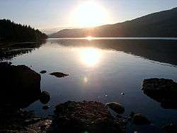 Early morning view | |
| Location | Stirling, Scotland |
| Coordinates | 56°13′N 4°19′W / 56.217°N 4.317°WCoordinates: 56°13′N 4°19′W / 56.217°N 4.317°W |
| Type | freshwater loch |
| Primary inflows | Black Water |
| Basin countries | United Kingdom |
| Max. length | 6 km (3.7 mi) |
| Max. depth | 33 m |
| Surface elevation | 82 m |
Loch Venachar (Scottish Gaelic: Loch Bheannchair) is a freshwater loch in Stirling district, Scotland, situated between Callander and Brig o' Turk. It lies approximately 82 metres above sea level, and is 6 kilometres (3.7 mi) long with a maximum depth of approximately 33 metres.
The Black Water discharges from Loch Achray into the western end of Loch Venachar, and at the eastern end emerges Eas Gobhain which joins with the River Leny at Callander to form the River Teith.
The south shore of the loch is covered by woodland containing numerous forest tracks, some leading over the hills to the Lake of Menteith and some leading westward along the loch to Loch Achray and the Trossachs.
Invertrossachs House, which was visited by Queen Victoria in 1869, is also located on the south shore. Venachar sailing club is accessible from the Invertrossachs private road. This sailing club uses the loch for regular racing events between March and October.[1] To the North of the loch is Scotland's first highland Ben, Ben Ledi.
A brown trout stocking programme recommenced in 2016 under the management of the Loch Venachar Association and the loch is well stocked with pike. Fishing is available, by permit, from the shore and by boat.[2]
References
External links
- Loch Venachar Association website
- Loch Venachar on “In Callander” website
- Loch Venachar Sailing Club website
| Wikimedia Commons has media related to Loch Venachar. |