Lock and Dam No. 20
 Mississippi River Lock and Dam number 20 | |
| Location |
Lima Township, Adams County, Illinois / Canton Township, Lewis County, Missouri, near Canton, Missouri |
|---|---|
| Coordinates | 40°08′37″N 91°30′46″W / 40.14361°N 91.51278°WCoordinates: 40°08′37″N 91°30′46″W / 40.14361°N 91.51278°W |
| Construction began | 1932 |
| Opening date | November 20, 1935 |
| Construction cost | US$4.45 million |
| Operator(s) | United States Army Corps of Engineers |
| Dam and spillways | |
| Impounds | Upper Mississippi River |
| Length | 2,369 feet (722 m) |
| Reservoir | |
| Creates | Pool 20 |
| Total capacity | 58,000 acre·ft (0.072 km3) |
| Catchment area | 134,300 sq mi (348,000 km2) |
|
Lock and Dam No. 20 Historic District | |
  | |
| Location | 1⁄2 mi (800 m) N of Henderson St, Canton, Missouri |
| Area | 83.9 acres (34.0 ha) |
| Built | 1935 |
| Architect | COE; Abbott, Edwin E. |
| MPS | Upper Mississippi River 9-Foot Navigation Project MPS |
| NRHP Reference # | 04000180[1] |
| Added to NRHP | March 10, 2004 |
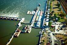
Lock and Dam No. 20 is a lock and dam located on the Upper Mississippi River, about one mile upstream from Canton, Missouri.
The structure is located at river mile 343.1. It includes a 2,369 feet (722 m) long dam, 40 tainter gates, 3 roller gates, and a lock chamber that is 110 feet (34 m) wide by 600 feet (183 m) long. There is also an incomplete auxiliary lock. In 2004, the facility was listed in the National Register of Historic Places as Lock and Dam No. 20 Historic District, #04000180 covering 839 acres (340 ha), 1 building, 6 structures, 3 objects.
History
The Lock and Dam are on the site of the former town of Tully, Missouri. Tully was founded in 1834 and became a thriving river port and regional business hub until being virtually destroyed by major flooding in 1851.[2] Left a crumbling "ghost town", what little that remained of Tully was finally removed during Lock and Dam No. 20's construction.[3]
References
- ↑ National Park Service (2009-03-13). "National Register Information System". National Register of Historic Places. National Park Service.
- ↑ "A Directory of Towns, Villages, and Hamlets Past and Present of Lewis County, Missouri". Springfield-Greene County Public Library. 2013. Retrieved 21 July 2013.
- ↑ "Canton Historic Marker". Missouri Historical Society text via Waymarking.com. 2013 [1957]. Retrieved 23 July 2013.
External links
| Locks and dams of the Upper Mississippi River | ||
|---|---|---|
| Upstream: Lock and Dam No. 19 |
Downstream: Lock and Dam No. 21 | |