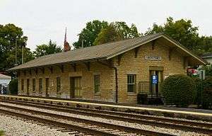
Lockport station (Illinois)
 | ||||||||||||||||||||||||||
| Location |
13th Street & State Street Lockport, Illinois | |||||||||||||||||||||||||
| Coordinates | 41°35′06″N 88°03′37″W / 41.5851°N 88.0602°WCoordinates: 41°35′06″N 88°03′37″W / 41.5851°N 88.0602°W | |||||||||||||||||||||||||
| Owned by | City of Lockport | |||||||||||||||||||||||||
| Line(s) | ||||||||||||||||||||||||||
| Platforms | 2 side platforms | |||||||||||||||||||||||||
| Tracks | 2 | |||||||||||||||||||||||||
| Connections |
| |||||||||||||||||||||||||
| Construction | ||||||||||||||||||||||||||
| Disabled access | Yes | |||||||||||||||||||||||||
| Other information | ||||||||||||||||||||||||||
| Fare zone | G | |||||||||||||||||||||||||
| History | ||||||||||||||||||||||||||
| Opened | 1863 | |||||||||||||||||||||||||
| Traffic | ||||||||||||||||||||||||||
| Passengers | 352 (avg. weekday 2014)[1] | |||||||||||||||||||||||||
| Rank | 131 out of 236[2] | |||||||||||||||||||||||||
| Services | ||||||||||||||||||||||||||
| ||||||||||||||||||||||||||
Lockport is a station on Metra's Heritage Corridor in Lockport, Illinois. The station is 32.9 miles (52.9 km) away from Union Station, the northern terminus of the line.[3] In Metra's zone-based fare system, Lockport is in zone G. The station is used only during rush hours.
Lockport Station was originally built in 1863 by the Chicago and Alton Railroad. The tracks run parallel to the Illinois and Michigan Canal, and shares the right-of-way with Amtrak's Lincoln Service and Texas Eagle trains, however, no Amtrak trains stop here.
Three blocks east of the station is the meeting place of the Blackhawk Chapter of the National Railroad Historical Society at the Gladys Fox Museum.[4]
Bus connections
Pace "Route 834 – Joliet/Downers Grove". PaceBus.com. Chicago: Pace Suburban Bus Service.