Lofgren Peninsula
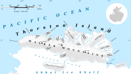
Lofgren Peninsula (72°12′S 96°4′W / 72.200°S 96.067°WCoordinates: 72°12′S 96°4′W / 72.200°S 96.067°W) is an ice-covered peninsula about 22 nautical miles (40 km) long, ending at Cape Menzel projecting between Cadwalader Inlet and Morgan Inlet on the northeast side of Thurston Island, Antarctica. It was discovered in helicopter flights from the USS Burton Island and the USS Glacier of the U.S. Navy Bellingshausen Sea Expedition in February 1960, and was named by the Advisory Committee on Antarctic Names for Charles E. Lofgren, personnel officer with the Byrd Antarctic Expedition, 1928–30.[1]
Maps
- Thurston Island – Jones Mountains. 1:500000 Antarctica Sketch Map. US Geological Survey, 1967.
- Antarctic Digital Database (ADD). Scale 1:250000 topographic map of Antarctica. Scientific Committee on Antarctic Research (SCAR), 1993–2016.
References
- ↑ "Lofgren Peninsula". Geographic Names Information System. United States Geological Survey. Retrieved 2013-06-28.
![]() This article incorporates public domain material from the United States Geological Survey document "Lofgren Peninsula" (content from the Geographic Names Information System).
This article incorporates public domain material from the United States Geological Survey document "Lofgren Peninsula" (content from the Geographic Names Information System).