Lofton Reservoir
| Lofton Reservoir | |
|---|---|
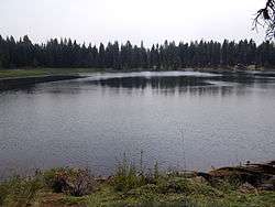 Main body of Lofton Reservoir | |
| Location | Lake County, Oregon |
| Coordinates | 42°15′54″N 120°49′11″W / 42.26500°N 120.81972°WCoordinates: 42°15′54″N 120°49′11″W / 42.26500°N 120.81972°W |
| Type | Reservoir |
| Primary inflows | Fishhole creek watershed |
| Catchment area | 2 square miles (5.2 km2) |
| Basin countries | United States |
| Surface area | 33 acres (130,000 m2) |
| Average depth | 8 feet (2.4 m) |
| Water volume | 650 acre feet (800,000 m3) |
| Surface elevation | 6,100 feet (1,900 m) |
Lofton Reservoir, also known locally as None, is an earthen impoundment of water located 6,100 feet (1,900 m) above sea level in Lake County, Oregon, United States. It is 20 miles (32 km) southeast of Bly, used primarily for irrigation & recreation purposes.[1] Construction was completed in 1962. It is owned by Oregon Department of Fish and Wildlife.
Statistics
Lofton reservoir has an average surface area of 33 acres (130,000 m2), an average volume of 650 acre feet (800,000 m3),[2] and a 2-square-mile (5.2 km2) drainage basin.[2] It has an average depth of 18 feet (5.5 m), and a maximum depth of 31 feet (9.4 m). The Lofton Reservoir stands 32 feet (9.8 m) tall and 265 feet (81 m) long.
Fauna
Rainbow trout and brook trout are common in the lake.[1]
Recreation
Lofton Reservoir has a pack it in-pack it out campground located around the lake.[1] Popular activities include fishing and boating limited to electric motors.
See also
References
- 1 2 3 Dow, Fred and Suzanne (2009). U. S. National Forest Campground Guide: Pacific Northwest - Oregon. Moon Canyon Publishing. p. 136. ISBN 978-1-56691-604-2.
- 1 2 "Lofton Reservoir, southcentral Oregon". FindLakes.com. Retrieved August 28, 2012.