Lomná (river)
| Lomná Łomna | |
|---|---|
 Lomná in Dolní Lomná | |
| Country | Czech Republic |
| Basin | |
| Main source |
Moravian-Silesian Beskids 870 m (2,850 ft) |
| River mouth | Olza River |
| Basin size | 70.6 km2 (27.3 sq mi) |
| Physical characteristics | |
| Length | 17.5 km (10.9 mi) |
| Discharge |
|
![]() Lomná (Polish: Łomna , Cieszyn Silesian: Łómno ) also known as Lomňanka (Polish: Łomnianka , Cieszyn Silesian: Łómnianka ) is a 17 kilometres (11 mi)-long river in Frýdek-Místek District, Moravian-Silesian Region, Czech Republic, in the historical region of Cieszyn Silesia.
Lomná (Polish: Łomna , Cieszyn Silesian: Łómno ) also known as Lomňanka (Polish: Łomnianka , Cieszyn Silesian: Łómnianka ) is a 17 kilometres (11 mi)-long river in Frýdek-Místek District, Moravian-Silesian Region, Czech Republic, in the historical region of Cieszyn Silesia.
It is the left tributary of the Olza River, to which it enters in Jablunkov (Jabłonków). It originates near the border with Slovakia and flows through the villages of Horní Lomná (Łomna Górna), Dolní Lomná (Łomna Dolna) and Bocanovice (Boconowice).
It was mentioned in 1592 as przi rzece Lomny. The name is derived from the words łom (clatter, rumble, susurrus) or załom (turn, bend).[1]
 Lomná in Dolní Lomná
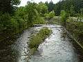 Lomná in Dolní Lomná
Footnotes
- ↑ Mrózek, Robert (1984). Nazwy miejscowe dawnego Śląska Cieszyńskiego [Local names of former Cieszyn Silesia] (in Polish). Katowice: Uniwersytet Śląski w Katowicach. p. 97. ISSN 0208-6336.
References
- Cicha, Irena; Jaworski, Kazimierz; Ondraszek, Bronisław; Stalmach, Barbara; Stalmach, Jan (2000). Olza od pramene po ujście. Český Těšín: Region Silesia. pp. 16, 18. ISBN 80-238-6081-X.
| Wikimedia Commons has media related to Lomná River. |
Coordinates: 49°34′42.58″N 18°45′50.70″E / 49.5784944°N 18.7640833°E
This article is issued from Wikipedia - version of the 6/3/2016. The text is available under the Creative Commons Attribution/Share Alike but additional terms may apply for the media files.