Lone Pine Airport
| Lone Pine Airport | |||||||||||||||
|---|---|---|---|---|---|---|---|---|---|---|---|---|---|---|---|
|
2006 USGS airphoto | |||||||||||||||
| IATA: none – ICAO: none – FAA LID: O26 | |||||||||||||||
| Summary | |||||||||||||||
| Airport type | Public | ||||||||||||||
| Location | Lone Pine, California | ||||||||||||||
| Elevation AMSL | 3,680 ft / 1,122 m | ||||||||||||||
| Coordinates | 36°35′17.760″N 118°03′07.31″W / 36.58826667°N 118.0520306°WCoordinates: 36°35′17.760″N 118°03′07.31″W / 36.58826667°N 118.0520306°W | ||||||||||||||
| Map | |||||||||||||||
 O26 Location of Lone Pine Airport | |||||||||||||||
| Runways | |||||||||||||||
| |||||||||||||||
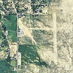
Lone Pine Airport (FAA LID: O26) is a public airport located one mile (1.6 km) southeast of Lone Pine (Geographic coordinates N36-35.30; W118-03.12) serving Inyo County, California, USA. The airport has two runways and is mostly used for general aviation. Charts: San Francisc; L5.
Facilities
Lone Pine Airport has two runways:
- Runway 16/34: 4,000 x 60 ft (1,219 x 18 m). Surface: Asphalt
- Runway 13/31: 2,400 x 100 ft (732 x 30 m). Surface: Dirt
World War II
During World War II, the airport was used as a contract flying school by the United States Army Air Forces. The contract flying school operated between 1942 and 1944. The school also controlled several auxiliary airfields:
- Adamson Landing Field 36°15′23″N 117°59′52″W / 36.25639°N 117.99778°W
- Independence Auxiliary Field 36°48′50″N 118°12′15″W / 36.81389°N 118.20417°W
- Inyo County Auxiliary Field 36°44′13″N 118°08′42″W / 36.73694°N 118.14500°W
See also
References
![]() This article incorporates public domain material from the Air Force Historical Research Agency website http://www.afhra.af.mil/.
This article incorporates public domain material from the Air Force Historical Research Agency website http://www.afhra.af.mil/.
| Wikimedia Commons has media related to Lone Pine Airport. |
- Airport Master Record (FAA Form 5010), also available as a printable form (PDF)
External links
- Resources for this airport:
- FAA airport information for O26
- AirNav airport information for O26
- FlightAware airport information and live flight tracker
- SkyVector aeronautical chart for O26
| Flying Training |
|  | ||||||
|---|---|---|---|---|---|---|---|---|
| Technical Training |
| |||||||
This article is issued from Wikipedia - version of the 12/25/2015. The text is available under the Creative Commons Attribution/Share Alike but additional terms may apply for the media files.