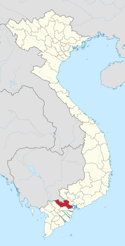
Long An Province
| Long An Province Tỉnh Long An | |
|---|---|
| Province | |
 Location of Long An within Vietnam | |
| Coordinates: 10°40′N 106°10′E / 10.667°N 106.167°ECoordinates: 10°40′N 106°10′E / 10.667°N 106.167°E | |
| Country |
|
| Region | Mekong Delta |
| Capital | Tân An |
| Government | |
| • People's Council Chair | Trương Văn Tiếp |
| • People's Committee Chair | Dương Quốc Xuân |
| Area[1] | |
| • Total | 4,495.5 km2 (1,735.7 sq mi) |
| Population (2004)[1] | |
| • Total | 1,477,300 |
| • Density | 330/km2 (850/sq mi) |
| Demographics | |
| • Ethnicities | Vietnamese, others |
| Time zone | ICT (UTC+7) |
| Calling code | 72 |
| ISO 3166 code | VN-41 |
| Website |
eng |
Long An (![]() listen) is a province in the Mekong Delta region of southern Vietnam. The provincial capital is Tân An, and other major cities include Bến Lức, Đức Hòa and Mộc Hóa. There are 13 districts within the province.[2]
listen) is a province in the Mekong Delta region of southern Vietnam. The provincial capital is Tân An, and other major cities include Bến Lức, Đức Hòa and Mộc Hóa. There are 13 districts within the province.[2]
Under the Khmer Empire, before the Vietnamese annexation of the region, the province was known as ឈ្មោះថ្មី, Chmu Thmey ("New Name") or កំពង់គោ, Kompong Kô ("Cow Shore").
Geography
Long An is situated in an advantageous position in the Southern Key Economic Region of Vietnam. It serves as a bridge between Ho Chi Minh City in the north and 12 provinces in the Mekong Delta in the south. The province also has Cambodia to its west and the East Sea (South China Sea) to its east.
Long An is a low-lying coastal region, and therefore some areas of it are subject to flooding during the rainy season, which lasts from the beginning of August until November.
The province has numerous rivers. Two of the main ones are the Vàm Cỏ Đông and Vàm Cỏ Tay, which connect with the Tiền to form a larger river system. Another important river in the region is the Soài Rạp.
Administrative divisions
Long An is subdivided into 15 district-level sub-divisions:
- 13 districts:
- 1 district-level town:
- Kiến Tường
- 1 provincial city:
- Tân An (capital)
They are further subdivided into 14 commune-level towns (or townlets), 166 communes, and 12 wards.
Climate change concerns
Being a low-lying coastal region, Long An is particularly susceptible to floods resulting from rises in sea level due to climate change. The Climate Change Research Institute at Can Tho University (Trường Đại học Cần Thơ), in studying the possible consequences of climate change, has predicted that 49% of Long An province is expected to be flooded if sea levels rise by 1 meter.[3]
University
Long An is home to two large universities:
- Long An University of Economics and Industry (Trường Đại Học Kinh Tế Công Nghiệp Long An)
- Tan Tao University (Trường Đại Học Tân Tạo)
References
- 1 2 Statistical Handbook of Vietnam 2014, General Statistics Office Of Vietnam
- ↑ Long An Government
- ↑ Mekong Delta: more flood and drought. VietnamNet Bridge. March 19, 2009.
External links
- Official website (Vietnamese)
- Official website (English)
 |
Prey Veng Province, |
Svay Rieng Province, |
Tây Ninh Province Bình Dương Province |
 |
| Đồng Tháp Province | |
Ho Chi Minh City | ||
| ||||
| | ||||
| Tiền Giang Province |
Template:Vietnam