Long Newnton
| Long Newnton | |
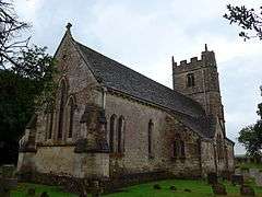 Holy Trinity Church, Long Newnton |
|
 Long Newnton |
|
| Population | 211 (2011 Census) |
|---|---|
| Civil parish | Long Newnton |
| District | Cotswold |
| Shire county | Gloucestershire |
| Region | South West |
| Country | England |
| Sovereign state | United Kingdom |
| Police | Gloucestershire |
| Fire | Gloucestershire |
| Ambulance | South Western |
| EU Parliament | South West England |
|
|
Coordinates: 51°37′35″N 2°08′00″W / 51.6264°N 2.1333°W
Long Newnton is a small village and civil parish in Gloucestershire, England (historically in Wiltshire), situated on the main road (B4014) between Malmesbury (2 km NW) and Tetbury (5 km S). It is near the SW end of the Cotswolds. In 2010 its population was estimated to be 199,[1] increasing to 211 at the 2011 census,[2] 109 males and 102 females.[3]
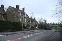
The village has no shops: just a church (Holy Trinity Church) [4] and between 30 and 60 houses. The nearest large towns are Cheltenham and Swindon. Long Newnton is about an hour from Bristol, Bath, Gloucester and Oxford. Close to Long Newnton is the Estcourt estate which is now owned by an Arabian horse owner.
However Estcourt House and other features named for the Estcourt family are actually in the neighbouring parishes of Shipton Moyne and Tetbury Upton. The village was associated for hundreds of years with the Estcourt family, and the church living was in the gift of the family. The Estcourt fund finances extra-curricular activities for young people aged 13 and over living in Long Newnton.
Holy Trinity Church, an Anglican church in the Early English style, is a Grade II listed building.[5]
The Monarch's Way passes through the parish.
History

In 1868 Long Newnton was Described as:
"a parish in the hundred of Malmesbury, county Wilts, 1½ mile E. of Tetbury, in Gloucestershire, and 4 miles N.W. of Malmesbury. It was called by the Saxons Newantune, and had right of common granted by King Athelstane. The parish is bounded on the W. by a branch of the river Avon. The village, which is small, and wholly agricultural, is situated on the road from Gloucester to Portsmouth. The tithes have been commuted for a rent-charge of £365, with a glebe of 23 acres. The living is a rectory* in the diocese of Gloucester and Bristol, value £370. The church, dedicated to the Holy Trinity, is a modern structure, except the tower, rebuilt at the expense of the landholders. The peal of bells has recently been increased to six. There is a village school, supported by subscription. The Right Hon. Thomas H. S. Sotheron Estcourt, M. P., is lord of the manor."[6]
During the 1870s Long Newnton was described as follows:
"The village stands near Akeman-street, and near the boundary with Gloucestershire, 1½ mile E of Tetbury, and 6½ S W by W of Tetbury-road r. station; was known to the Saxons as Newantune; and has a post-office under Tetbury. The parish comprises 2,289 acres."[7]
During the First World War, RAF Long Newnton was built on a farm, an RAF base that consisted of an aerial gunnery range, and then was used for storage of ammunition and bombs. When the war was finished great efforts were made to remove the bombs and ammunition from the site for safety. In 1939 RAF Long Newnton was made into a decoy airfield, as part of the planning for World War Two which involved strategic lighting to fool Germans yet allow the RAF fighters to avoid landing there. In 1940 the site became a training school as part of the RAF and a relief landing ground.[8] However by 1947 the RAF base was completely unused and the land was bought privately for agricultural purposes. Three Solar farms now sit in its place however some remains of the RAF base have survived and these have become a magnet for those interested in the history.[9]
Historically the village was also known as "Long Newnton". The Fosse Way forms part of the Parish Boundary and also the country boundary with Wiltshire. Long Newnton was one of several parishes which were transferred from Wiltshire to Gloucestershire in 1930[10]
Economy
The current average house price in Long Newnton is £543,000 this represents a strong economy. Another representation of a strong, and growing economy is that house prices have increased by an average of £8,806 in the last three months. In the last 20 years house values in Long Newnton have increased by £492,121 this is significant compared to the average increase for England of £227,609.[11]
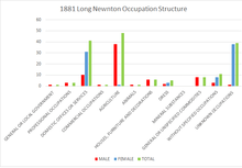
Earliest records show that through history, the Long Newnton economy has significantly relied upon agriculture as a main employer. Records from 1811 show that out of the 44 families living in the Parish, 34 of them were 'chiefly employed in Agriculture'[12] is further supported by the bar chart which shows that in 1881 agriculture continued to be the main occupation for men with 48 men employed by the trade. However by 2011, Long Newnton were no longer dependent on agriculture for the economy, while only 9 were employed in agriculture, 15 people were employed in Professional, Scientific and Technical Activities, making it the most popular trade in Long Newnton.[13] This suggests that although in the past Long Newnton has been reliant on agriculture for trade and its economy, this is becoming less important as redients have taken up occupation in modern, technically advanced employment.
Transport
The B4014 Road runs through Long Newnton and is the main access to the village, this leads to the A433 (Bath Road) in Tetbury and the A429.
Demographics
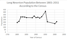
As can be seen from the line graph, throughout 1801 to 2011 the population of Long Newnton has varied between 150 and 450. Population records start from the 1801 census when the population was just under 196, this stayed fairly stable until 1851 when the population decreased by 11 and continued to decrease until 1891 when it rose to 323. Between 1891 and 1931 it continued to vary between 323 and 284 before spiking significantly in 1951 to 419, this spike in population correlates with the Parish becoming part of Gloucestershire along with the village of Ashley and proposal transfer of Marston Maisey in 1930.[14] Another decrease occurred in 1961 leaving a population of just 210.[15][16] The population of Long Newnton then stabilised and was recorded at 211 in both 2001 and 2011.[17]
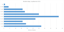
The Population Pyramid shows that Long Newnton has, what could be described as an economically stable demographic structure because it does not suffer from either a young or an aging population. Instead it benefits from having a population where the majority of the people living there would be expected to be economically active, 154 of the 210 people are within 21 years old to 70 years old.[18]
References
- ↑ Parish Population Estimates for Gloucestershire Gloucestershire County Council
- ↑ "Long Newnton (Parish):Key Figures for 2011 Census: Key Statistics". Neighbourhood Statistics. Office for National Statistics. Retrieved 21 March 2016.
- ↑ "Long Newnton (Parish):Key Figures for 2011 Census: Key Statistics". Neighbourhood Statistics. Office of National Statistics. Retrieved 28 January 2016.
- ↑ "Parish Finder". The Church of England. Church Commissioners for England. Retrieved 18 April 2016.
- ↑ http://www.britishlistedbuildings.co.uk/en-425521-holy-trinity-church-long-newnton-glouces#.VrOBGUCjOSo
- ↑ Hamilton, N E S A (1868). The National Gazetteer of Great Britain and Ireland. London: Virtue.
- ↑ Wilson, John Marius (1870–72). Imperial Gazetteer of England and Wales. Edinburgh: A. Fullerton & Co.
- ↑ Drew, Richard. "RAF Long Newnton. Wiltshire". www.atlantikwall.co.uk. Retrieved 23 March 2016.
- ↑ "Long Newnton - Airfields of Britain Conservation Trust UK". www.abct.org.uk. Airfields of Britain Conservation Trust. Retrieved 23 March 2016.
- ↑ "County Filter: Long Newnton". Genuki UK and Ireland Genealogy. Anthony L. Jones in co-operation with the Cowbridge and Local History Society and the Cowbridge Museum Trust. Retrieved 18 April 2016.
- ↑ "House prices in Long Newnton. Property values - Zoopla". www.zoopla.co.uk. Zoopla. Retrieved 16 March 2016.
- ↑ "Observations and Enumeration Abstract". Histpop, Online Historical Population Reports. University of Essex. Retrieved 17 April 2016.
- ↑ "Industry, 2011 (QS605EW)". Neighbourhood Statistics. Office for National Statistics.
- ↑ "Gloucestershire Archives Homepage". www.gloucestershire.gov.uk. Gloucestershire County Council. Retrieved 23 March 2016.
- ↑ "Long Newnton CP/Ch through time | Population Statistics |Total Population". A Vision of Britain Through Time. GB Historical GIS / University of Portsmouth. Retrieved 17 March 2016.
- ↑ "Long Newnton CP/Ch through time | Population Statistics | Total Population". A Vision of Britain Through Time. GB Historical GIS/ University of Portsmouth. Retrieved 17 March 2013.
- ↑ "Long Newnton (Parish):Key Figures for 2011 Census: Key Statistics". Neighbourhood Statistics. Office for National Statistics. Retrieved 17 March 2016.
- ↑ "Age by Single Year, 2011 (QS103EW)". Neighbourhood Statistics. Office for National Statistics. Retrieved 18 April 2016.