Long Tom Pass
| Long Tom Pass | |
|---|---|
|
The Long Tom Pass looking along the R37 towards Sabie | |
| Elevation | 2,150 m (7,054 ft)[1] |
| Location | Between Sabie and Lydenburg, South Africa |
| Range | Drakensberg Mountains |
| Coordinates | 25°08′28.5″S 30°36′17.8″E / 25.141250°S 30.604944°ECoordinates: 25°08′28.5″S 30°36′17.8″E / 25.141250°S 30.604944°E |
 Location in South Africa | |
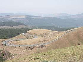
Long Tom Pass is situated in the Mpumalanga province, on the Regional Road R37 between Lydenburg and Sabie (South Africa). It is named after the famous Long Tom cannon.[1]
Route
The route up Long Tom Pass starts at 1456m and climbs 682 vertical metres to an altitude of 2138m at its end. The summit of the pass lies at an altitude of 2150m. The pass is part of the Mpumalanga Panorama Route and carries appropriately heavy traffic both tourist and commercial. The pass is prone to heavy mist and can be dangerous in low visibility conditions. [1]
Long Tom Monument
A monument commemorating the last use of the Boer 155 mm Creusot Long Tom guns during the Second Boer War is located in the pass, about 21 kilometres (13 mi) from Sabie.[2]
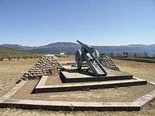
Long Tom Monument
References
- 1 2 3 "Long Tom Pass". Mountain Passes South Africa. Retrieved 18 June 2015.
- ↑ "Long Tom Cannon Monument". Retrieved 2009-11-16.
This article is issued from Wikipedia - version of the 8/10/2016. The text is available under the Creative Commons Attribution/Share Alike but additional terms may apply for the media files.