Loon Lake (California)
| Loon Lake Reservoir | |
|---|---|
 | |
| Location |
Eldorado National Forest El Dorado County, California |
| Coordinates | 38°59′17″N 120°19′52″W / 38.988°N 120.331°WCoordinates: 38°59′17″N 120°19′52″W / 38.988°N 120.331°W |
| Type | Reservoir |
| Primary inflows | Buck-Loon Tunnel |
| Primary outflows | Gerle Creek |
| Catchment area | 5,200 acres (2,100 ha) |
| Basin countries | United States |
| Max. length | 3.5 mi (5.6 km) |
| Water volume | 76,200 acre·ft (94,000,000 m3) |
| Surface elevation | 6,410 ft (1,950 m) |
| References | U.S. Geological Survey Geographic Names Information System: Loon Lake |
Loon Lake Reservoir is a reservoir in the Eldorado National Forest of El Dorado County, California, United States. The 76,200 acre·ft (94,000,000 m3) lake is formed by Loon Lake Dam, completed in 1963 as part of the Upper American River Project by Sacramento Municipal Utility District to conserve spring snow melt runoff for use during the summer and autumn for hydroelectric power production. Loon Lake Dam impounds water at the headwaters of Gerle Creek which, prior to the dam, flowed intermittently through (natural) Loon and Pleasant Lakes. But most of the water now stored in Loon Lake Reservoir arrives from Buck Island Reservoir in the adjacent Rubicon River watershed by way of the Buck-Loon Tunnel. Nearby is Loon Lake Chalet, a popular winter recreation destination. In summer, a boat ramp for water sports and camping are available, but the area is less popular than nearby Union Valley Reservoir and Rubicon Trail.
It is popularly referred to as Loon Lake, although strictly speaking this is the name of the former lake now inundated by the dam. Boaters still refer to the northeast portion of the reservoir as the Pleasant Lake Arm, the portion over the inundated Pleasant Lake.
History
Development
In 1884, Loon Lake Reservoir was constructed to provide water supply to Georgetown Ridge for mining. It was owned and operated by the Georgetown Divide Water Co. whom used it for irrigation and as a canal system from Gerle Creek to Georgetown Ridge. In 1943, E. F. Sullivan of the Bureau of Reclamation proposed that Loon Lake be used for matters of power generation. In 1948, the Georgetown Divide Public Utility District (GDPUD) applied for appropriative rights from the State of California to appropriate 260,000 acre-feet of water from the American River basin. This was in order to divert water through Loon Lake and Gerle Creek for purposes of irrigation, stock-watering and domestic use.[1]
Water Rights
Originally, the Georgetown Divide Public Utility District (GDPUD) had obtained appropriative water rights from the State Water Resources Control Board. Also, GDPUD exercised pre-1914 rights for diversion of water from several tributaries of Pilot Creek in the South Fork American River. The Georgetown Divide Water Company and other water companies invested that included Sierra Pacific Power Company, Loon Lake Water and Power Company, California Water Company and the Pilot Creek Water Company claimed pre-1914 rights in the South Fork Rubicon and Pilot Creek drainages for years prior to the 20th century. These rights included storage in Loon Lake, diversion from South Fork Rubicon River, Gerle Creek and Pilot Creek and all its tributaries. The water storage in Loon Lake was diverted and re-diverted into a canal system which eventually made its way from the South Fork Rubicon drainage into Pilot Creek drainage.[2]
A deed was signed in 1952 by GDPUD, whom paid for the rights and operation of all facilities in the Georgetown service area and the Georgetown Divide Water Company that included Loon Lake, diversions from Rubicon and Onion Creek to all Pilot Creek watersheds and diversions. Between the years of 1940 and 1950, Sacramento Municipal Utility District (SMUD) was interested in obtaining rights to facilities of the GDPUD in the South Fork Rubicon River watershed that included Loon Lake, for development of SMUD's Upper American River Project (UARP). In 1961, an agreement was made between SMUD and GDPUD and the associated rights to the South Fork Rubicon watershed were turned over. The pre-1914 water rights of the facilities in the Upper Rubicon watershed were also turned over to SMUD in the written deed. SMUD then applied for appropriative water rights in the Upper Rubicon watershed which included Loon Lake, diversions into Loon Lake and diversions out of the South Fork Rubicon basin into Silver Creek.[2]
Hydroelectric Project
The Upper American River Hydroelectric Project (UARP) was constructed by SMUD between 1959 and 1985 and began revenue operation in 1961. The watersheds that supply the UARP, encompassing some 674 square miles, are characterized by the mountains in the east and incised canyons in the west. Most of the UARP lies on Eldorado National Forest and includes eight powerhouses and 11 reservoirs.[3]
Loon Lake Facility
Loon Lake Reservoir lies the farthest upstream of all the UARP facilities. This development consists of a 1.6 mile long tunnel that diverts water from the Buck Island Reservoir to the Loon Lake Reservoir. Loon Lake Dam consists of a side channel spillway adjacent to the main dam, an auxiliary dam, and an and earthfill dike. Another component, the Loon Lake Powerhouse, is an underground power generator that is located more than 1,000 ft below the Loon Lake Reservoir and has a tunnel that runs from the powerhouse to the Gerle Creek Reservoir. Energy is conveyed using two transmission lines (69 kilovolts each): one runs between Loon Lake and Robbs Peak switchyards and the other runs between Loon Lake and Union Valley switchyards.[4]
Operation
SMUD uses the UARP generate electricity. This also serves to safeguard the reliability of the electrical transmission system SMUD operates. The Balancing Authority that SMUD operates within is the zone or boundary that it balances power and interchanges with other power grids. The Loon Lake, Ice House and Union Valley Reservoirs generate about 90% of the total UARP storage during the peak winter and spring snowmelt seasons. In the mid-summer the reservoirs let out water storage to generate more power. The Rubicon and Buck Island Reservoirs capture and divert water into Loon Lake to produce the power it generates.[4] The storage at Loon Lake typically follows an annual cycle of increasing reservoir elevation in the spring and the highest point in the summer months. From the power generation over summer, the reservoir gradually lowers and allows for recharge in winter months and again storage to begin in spring. This annual cycle allows for a fluctuation of around 36 feet water elevation.[5]
CEQA
Loon Lake Reservoir as a part of the UARP, is required by SMUD under the California Environmental Quality Act to prepare mitigation strategies to avoid significant environmental effects. Many of the mitigation strategies are associated with geologic, aquatic and terrestrial resources that affect the species and composition of the natural ecosystem. Some of these impacts include: manipulation of reservoir levels, altering streamflow, concentration of pathogens due to human activity, altering quality of life for fish communities and also further threaten endangered species.[6]
Loon Lake Dam
Loon Lake Dam is a rockfill structure that is 0.4 mi (0.64 km) long by 108 ft (33 m) high. It includes a 250 ft (76 m) long side channel spillway on the right bank, a 910 ft (280 m) long by 95 ft (29 m) rockfill auxiliary dam, and an earthfill dike. Construction of the present dams began in 1962 with the dismantling of an older dam at the same site, constructed before 1910.

Water Quality
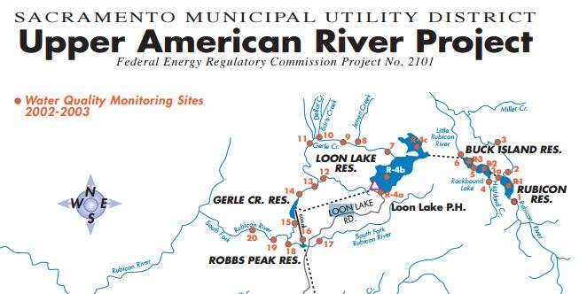
Loon Lake water sampling historically takes place at different elevations and is carried out by the USGS, SMUD and ecologists respectively. It is collected at four times during the year, first major rain, spring runoff, summer low flow and fall turnover. The last sampling took place in mid year 2000 near the mouth of Loon Lake Tunnel-Buck Island. The water flowing inward from Ellis Creek reported 21 °C and 11 °C directly from the Buck Island location. The sampling results show that Loon Lake Reservoir is a cold, clear and well oxygenated body of water. Maximum surface temperatures 13° and 15 °C and minimum temperatures were around 8 °C. Dissolved oxygen levels between 1999 and 2000 were between 8 and 9 mg/l throughout the water body. These results are consistent with past samples taken and show that Loon Lake Reservoir is close to or at 100 percent saturation. Other tests have shown that the reservoir also shows persistent clarity and that up to 36 feet in depth there is transparency.[7]
Riparian Areas
The Upper American River Project reservoirs including Loon Lake have vegetation that is considered upland type. Wetlands associated with these reservoirs are characterized by steep slope and well-drained substrates. The specific vegetation and terrain that is common there are mixed/conifer and fir trees, Huckleberry Oak, barren/rocky areas along the shoreline, wet meadows scattered throughout and Lodgepole Pines. There are two main types of wetlands that are common in this area, one of which is the lakeshore-basin meadow for seasonally and persistently flooded shorelines and there is the depressional meadows within swales. The largest wetland area is at the north end of the reservoir where it may contribute to the wetland conditions because of the accumulation of snowmelt and inundation from inflows. The total amount of area of wetland in the Loon Lake Reservoir is about 38 acres.[5]
Amenities
- Camping
The Loon Lake Campground is located on Highway 50 on Ice House Road on the South side of Loon Lake, about 23 miles east of Placerville. The campsite sits approximately at 6,500 ft elevation. Loon Lake Campground is typically open from mid July to mid October and the maximum amount of nights you can stay possible is 14 (annually). Single campsites only allow up to 1 vehicle and up to 6 people. There are 53 campsites total and reservations can be made at Recreation.gov.[8][9][10]
- Rubicon Trail
The Rubicon Trail is 4-wheel drive route that spans a total distance of 22 miles. Access the off-highway-vehicle segment of this trail is available near the base of Loon Lake Main Dam. More information can be found on County of El Dorado- Rubicon Trail.[11]
- Fishing

Rainbow trout is released every other week by the Department of Fish and Game [12]
- Boating
A boat ramp is available near the campground; no fee is charged to use it.
- Hiking
- Swimming
See also
References
- ↑ "USGS" (PDF).
- 1 2 "CA Water Boards- Water Rights" (PDF).
- ↑ "State Water Resources Control Board". www.waterboards.ca.gov. Retrieved 2016-05-15.
- 1 2 "CA Water Boards-Water Quality Cert" (PDF).
- 1 2 "UARP- Riparian Vegetation" (PDF).
- ↑ "CEQA- Mitigation Monitoring" (PDF).
- ↑ "UARP- Water Temp Report" (PDF).
- ↑ "USDA: Loon Lake Campground" (PDF).
- ↑ "LOON LAKE, CA". Recreation.gov. Retrieved 2016-05-15.
- ↑ "Loon Lake Area Camping". www.discoverechosummit.com. Retrieved 2016-05-15.
- ↑ "Information to the Rubicon Trail". www.edcgov.us. Retrieved 2016-05-15.
- ↑ "Eldorado - Nature & Science". www.fs.usda.gov. Retrieved 2016-05-15.
- Usgs.gov: Information about USGS station #11429500
- Sacramento Municipal Utility District.org: Repository of federal licensing documents
- Recreation.gov- Loon Lake
- USDA- Loon Lake Campground
- Discover Echo Summit-Loon Lake
- UARP- Water Report
- SWRCB- Water Quality Cert
- County of El Dorado- Rubicon Trail
- State Water Resources Control Board- GDPUD
- USGS.gov: Reservoir Sites in Sierra Nevada
- CEQA: Mitigation Monitoring
- SMUD- Riparian Vegetation & Wetlands
- CA Water Boards: UARP
- USDA- Recreational Activites