Lost Creek (South Fork Little Butte Creek)
For other places with the same name, see Lost Creek.
| Lost Creek | |
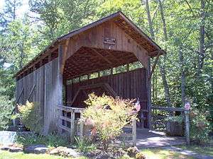 Lost Creek Bridge in 2007 | |
| Country | United States |
|---|---|
| State | Oregon |
| County | Jackson |
| Source | Cascade Range |
| - location | near Lost Lake, east of Medford |
| - elevation | 4,716 ft (1,437 m) [1] |
| - coordinates | 42°17′13″N 122°31′31″W / 42.28694°N 122.52528°W [2] |
| Mouth | South Fork Little Butte Creek |
| - location | near Lake Creek |
| - elevation | 1,824 ft (556 m) [2] |
| - coordinates | 42°23′11″N 122°35′04″W / 42.38639°N 122.58444°WCoordinates: 42°23′11″N 122°35′04″W / 42.38639°N 122.58444°W [2] |
| Basin | 17.2 sq mi (44.5 km2) [3] |
 Location of the mouth of Lost Creek in Oregon | |
Lost Creek is a tributary of the south fork of Little Butte Creek in Jackson County in the U.S. state of Oregon. Flowing north from near Lost Lake east of Medford, it enters the larger stream about 4 miles (6 km) upstream of the rural community of Lake Creek and about 20 miles (32 km) from the confluence of Little Butte Creek with the Rogue River. The only named tributary of Lost Creek is Coon Creek, which enters from the left.[4]
Lost Creek Bridge, a covered bridge, carries Lost Creek Road over the creek but is closed to vehicular traffic. The 39-foot (12 m) structure is the shortest covered bridge in Oregon.[5] It was added to the National Register of Historic Places in 1979.[6]
See also
References
- ↑ Source elevation derived from Google Earth search using Geographic Names Information System (GNIS) source coordinates.
- 1 2 3 "Lost Creek". Geographic Names Information System. United States Geological Survey. November 28, 1980. Retrieved February 16, 2016.
- ↑ "Little Butte Creek Watershed Assessment" (ZIP). Little Butte Creek Watershed Council. August 2003: 16. Retrieved February 16, 2016.
- ↑ "United States Topographic Map". United States Geological Survey. Retrieved February 16, 2016 – via Acme Mapper. The map includes mile markers along South Fork Little Butte Creek.
- ↑ "Lost Creek Covered Bridge" (PDF). Oregon Department of Transportation. Retrieved February 16, 2016.
- ↑ "Oregon National Register List" (PDF). June 6, 2011. p. 15. Retrieved August 31, 2007.
This article is issued from Wikipedia - version of the 9/11/2016. The text is available under the Creative Commons Attribution/Share Alike but additional terms may apply for the media files.