Loysburg Gap
Coordinates: 40°09′35″N 78°21′57″W / 40.1598017°N 78.3658475°W
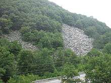
A view of the south side of the gap from the north side.
Loysburg Gap is a water gap where Pennsylvania Route 36 and the Yellow Creek pass through Tussey Mountain in near Loysburg in Bedford County, Pennsylvania, United States.
Yellow Creek flows eastward through the gap towards its junction with the Raystown Branch of the Juniata River. Periglacial boulder fields are present on both sides of the water gap, and the boulders are formed of the Silurian Tuscarora Formation.
This article is issued from Wikipedia - version of the 9/3/2016. The text is available under the Creative Commons Attribution/Share Alike but additional terms may apply for the media files.