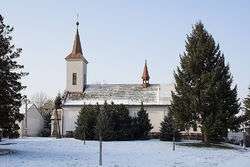
Ludslavice
| Ludslavice | |||
|---|---|---|---|
| Municipality | |||
 | |||
| |||
 Ludslavice | |||
| Coordinates: 49°17′59″N 17°32′26″E / 49.29972°N 17.54056°ECoordinates: 49°17′59″N 17°32′26″E / 49.29972°N 17.54056°E | |||
| Country |
| ||
| Region | Zlín | ||
| District | Kroměříž | ||
| Area | |||
| • Total | 5.84 km2 (2.25 sq mi) | ||
| Elevation | 211 m (692 ft) | ||
| Population (2006) | |||
| • Total | 498 | ||
| • Density | 85/km2 (220/sq mi) | ||
| Postal code | 768 52 | ||
| Website | http://www.ludslavice.cz | ||
Ludslavice is a village and municipality (obec) in Kroměříž District in the Zlín Region of the Czech Republic.
The municipality covers an area of 5.84 square kilometres (2.25 sq mi), and has a population of 498 (as at 3 July 2006).
Ludslavice lies approximately 11 kilometres (7 mi) east of Kroměříž, 12 km (7 mi) north-west of Zlín, and 242 km (150 mi) east of Prague.
References
| Wikimedia Commons has media related to Ludslavice. |
This article is issued from Wikipedia - version of the 4/7/2016. The text is available under the Creative Commons Attribution/Share Alike but additional terms may apply for the media files.