Luganville
| Luganville Kanal Santo | |
|---|---|
| Town | |
|
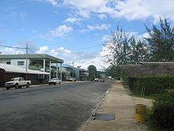
Luganville main street Boulevard Higinson | |
 Luganville Location in Vanuatu | |
| Coordinates: 15°32′S 167°10′E / 15.533°S 167.167°ECoordinates: 15°32′S 167°10′E / 15.533°S 167.167°E | |
| Country |
|
| Province | Sanma Province |
| Island | Espiritu Santo |
| Population (2009) | |
| • Total | 13,167 |
| Time zone | VUT (UTC+11) |
Luganville is the second largest city in Vanuatu. Its population is 13,167.[1]
The city is called Santo by people from Vanuatu's northern islands, who use Luganville as their big city. It is called Kanal (from French Second Canal) by rural residents of the large island of Espiritu Santo.
The main street that runs through Luganville contains most of the commercial businesses and is very wide as a result of the American base commander insisting that four army tanks could be driven side by side along the road. Small side streets and outlying roads cater for the residential zones. The main street contains the port at one end and the markets and municipal council building at the other end. In the centre there are two main types of stores: tourist boutiques and all-in-one stores (best described as a cross between a supermarket and a hardware store).
Population
The current population of Luganville is quite diverse. It comprises a vast majority of indigenous Ni-Vanuatu, and it also has a small population of Chinese and European descendants (English and French). Some of the locals, although residing in Luganville, come from other parts of Santo or different islands within Vanuatu.
Economy and services
Luganville has changed with the expansion of businesses and shops in the town. However, critics have claimed that Luganville has great potential and should have developed its economy further since Vanuatu gained its independence from Great Britain and France in 1980.
Luganville has the second largest hospital in Vanuatu called Northern District Hospital, built before independence by the French administration. The hospital provides services to residents in Luganville and people in rural parts of Santo. Additionally, the hospital serves people in other northern islands of Vanuatu, such as Banks. Still, the hospital is often underfunded by the central Government. It often relies on aid from overseas countries, most notably France, Australia, New Zealand, and China.
There are four (4) banks in Luganville, namely National Bank of Vanuatu [2][2], ANZ [3][3], Westpac [4][4], and BRED Bank [5][5].
Luganville has a main market place in town - and several small markets around town - which are popular with inexpensive local foods, fruits, vegetables and drinks. Luganville has a police station located in the centre of town. There are a small number of legal firms and real estate agencies in town.
Broadband internet became available to Luganville in late 2006.
Transportation
Luganville is one of Vanuatu's busiest ports, especially as a transshipment point for copra and cacao. Segond Channel, the body of water off the coast of Luganville behind Aore Island, provides the town with an excellent sheltered harbour.
The transportation in Luganville has changed dramatically and improved immensely. There are considerable numbers of taxis, buses, and public transport trucks providing service in and around town. The town is served by Santo-Pekoa International Airport.
During World War II about 40,000 United States military personnel were stationed in Luganville and it is estimated the between 400,000 and 500,000 military personnel took R & R on the island, operating 3 bomber airfields, a huge wharf and a nearby drydock. This era in Luganville's history is evident in the military-constructed Quonset huts still scattered around town.

Climate
| Climate data for Luganville | |||||||||||||
|---|---|---|---|---|---|---|---|---|---|---|---|---|---|
| Month | Jan | Feb | Mar | Apr | May | Jun | Jul | Aug | Sep | Oct | Nov | Dec | Year |
| Average high °C (°F) | 29 (85) |
29 (85) |
29 (84) |
28 (83) |
27 (81) |
27 (80) |
26 (79) |
26 (79) |
27 (80) |
27 (81) |
28 (83) |
29 (84) |
28 (82) |
| Average low °C (°F) | 24 (75) |
24 (75) |
24 (75) |
24 (75) |
23 (74) |
23 (73) |
22 (72) |
22 (71) |
22 (72) |
23 (73) |
23 (74) |
23 (74) |
23 (74) |
| Average precipitation mm (inches) | 325 (12.8) |
335 (13.2) |
340 (13.4) |
310 (12.2) |
211 (8.3) |
196 (7.7) |
163 (6.4) |
130 (5.1) |
160 (6.3) |
193 (7.6) |
216 (8.5) |
269 (10.6) |
2,929 (115.3) |
| Source: Weatherbase [6] | |||||||||||||
Twin towns – Sister cities
Luganville is twinned with:
-
 - Kota Kinabalu, Sabah, Malaysia.[7] (In process)
 -
 - Mont-Dore, New Caledonia.[8] (In process)
 -
 - Honiara, Solomon Islands.[9]
 -
 - Port Vila, Vanuatu.[10]
Notes
- ↑ 13,167 population - http://www.state.gov/r/pa/ei/bgn/2815.htm#people
- ↑ National Bank of Vanuatu - http://www.nbv.vu
- ↑ ANZ - http://www.locate.anz.com/anz/international
- ↑ Westpac - http://www.westpac.vu
- ↑ BRED Bank - http://www.bred.vu
- ↑ "Weatherbase: Historical Weather for Luganville, Vanuatu". Weatherbase. 2011. Retrieved on November 24, 2011.
- ↑ "Government of Republic of Vanuatu chooses KK as its main office in Malaysia". New Sabah Times. 5 May 2013. Retrieved 15 May 2013.
- ↑ "Sister city agreement reaping rewards". Vanuatu Daily Post. 6 May 2013. Retrieved 15 July 2013.
- ↑ "Luganville and Honiara establish sister city relations". Vanuatu Daily Post. 21 March 2013. Retrieved 15 July 2013.
- ↑ "Port Vila strengthens sister agreement with Luganville". Vanuatu Daily Post. 26 September 2012. Retrieved 15 July 2013.
External links
 Luganville travel guide from Wikivoyage