Lyefjell
| Lyefjell | |
|---|---|
| Village | |
|
View of the village | |
 Lyefjell  Lyefjell Location in Rogaland county | |
| Coordinates: 58°44′05″N 05°43′53″E / 58.73472°N 5.73139°ECoordinates: 58°44′05″N 05°43′53″E / 58.73472°N 5.73139°E | |
| Country | Norway |
| Region | Western Norway |
| County | Rogaland |
| District | Jæren |
| Municipality | Time |
| Area[1] | |
| • Total | 0.87 km2 (0.34 sq mi) |
| Elevation[2] | 208 m (682 ft) |
| Population (2015)[1] | |
| • Total | 2,253 |
| • Density | 2,590/km2 (6,700/sq mi) |
| Time zone | CET (UTC+01:00) |
| • Summer (DST) | CEST (UTC+02:00) |
| Post Code | 4347 Lye |
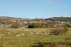
Lyefjell is a village in Time municipality in Rogaland county, Norway. The village is located in the hills about 5 kilometres (3.1 mi) east of the town of Bryne and about 5 kilometres (3.1 mi) north of the villages of Mossige and Undheim.
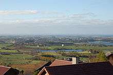
The village is a residential area that was built in the hills so that the flat, agricultural areas could continue to be used for farming. It is just to the south of the mountain Njåfjellet and the village has spectacular views of the flat plains of Jæren below.[3]
The 0.87-square-kilometre (210-acre) village has a population (2015) of 2,253 which gives the village a population density of 2,590 inhabitants per square kilometre (6,700/sq mi).[1] There is an elementary and middle school in Lyefjell as well as three large pre-schools.
References
- 1 2 3 Statistisk sentralbyrå (1 January 2015). "Urban settlements. Population and area, by municipality.".
- ↑ "Lyefjell, Time (Rogaland)" (in Norwegian). yr.no. Retrieved 2016-06-01.
- ↑ Store norske leksikon. "Lyefjell" (in Norwegian). Retrieved 2016-06-01.