Lyneham, Wiltshire
| Lyneham | |
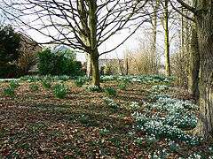
 Snowdrops in Lyneham |
|
 Lyneham |
|
| Population | 4,945 (civil parish in 2011)[1] |
|---|---|
| OS grid reference | SU025787 |
| Civil parish | Lyneham and Bradenstoke |
| Unitary authority | Wiltshire |
| Shire county | Wiltshire |
| Region | South West |
| Country | England |
| Sovereign state | United Kingdom |
| Post town | Chippenham |
| Postcode district | SN15 |
| Dialling code | 01249 |
| Police | Wiltshire |
| Fire | Dorset and Wiltshire |
| Ambulance | South Western |
| EU Parliament | South West England |
| UK Parliament | North Wiltshire |
| Website | Parish Council |
Coordinates: 51°30′25″N 1°57′58″W / 51.507°N 1.966°W
Lyneham is a large village in north Wiltshire, England, within the civil parish of Lyneham and Bradenstoke, and situated 4 miles (6.4 km) southwest of Royal Wootton Bassett, 5.5 miles (8.9 km) north of Calne and 11 miles (18 km) southwest of Swindon. The village is on the A3102 road between Calne and Wootton Bassett.
The civil parish includes the village of Bradenstoke and the hamlets of Preston[2] and The Banks.
RAF Lyneham
The former RAF Lyneham station (now MoD Lyneham) is at Lyneham. The RAF's C-130 Hercules fleet was based here until June 2011 and C-17 Globemasters from RAF Brize Norton made frequent visits. In 2012 all operations were transferred to Brize Norton in west Oxfordshire, 35 miles (56 km) to the northeast. Construction is underway to redevelop the base to house the proposed tri-forces Defence Technical Training College, which is scheduled to become operational in December 2015.
Amenities
Lyneham has a primary school.[3] Shops in Lyneham include a Tesco Express, Co-Operative store and selection of take-aways. There is also a restaurant, cafe and pubs. As well as a petrol station.
The Anglican Church of St Michael dates from the 14th century.[4] It has a stained glass window by Henry Haig which commemorates the 50th anniversary of RAF Lyneham.[5]
Local government
The civil parish elects a parish council called Lyneham and Bradenstoke Parish Council.[6] The parish is in the area of Wiltshire Council unitary authority, which is responsible for all significant local government functions.
An electoral ward of the same name exists. The ward stretches south east from the Lyneham area to incorporate the Clyffe Pypard parish. The total ward population taken from the 2011 census was 5,460. [7]
Climate
| Climate data for Lyneham: Average maximum and minimum temperatures, and average rainfall recorded between 1971 and 2000 by the Met Office. | |||||||||||||
|---|---|---|---|---|---|---|---|---|---|---|---|---|---|
| Month | Jan | Feb | Mar | Apr | May | Jun | Jul | Aug | Sep | Oct | Nov | Dec | Year |
| Average high °C (°F) | 6.6 (43.9) |
6.9 (44.4) |
9.4 (48.9) |
12.0 (53.6) |
15.7 (60.3) |
18.5 (65.3) |
21.2 (70.2) |
20.7 (69.3) |
17.7 (63.9) |
13.6 (56.5) |
9.6 (49.3) |
7.4 (45.3) |
13.3 (55.9) |
| Average low °C (°F) | 1.2 (34.2) |
1.0 (33.8) |
2.6 (36.7) |
3.7 (38.7) |
6.7 (44.1) |
9.7 (49.5) |
11.9 (53.4) |
11.8 (53.2) |
9.8 (49.6) |
6.8 (44.2) |
3.7 (38.7) |
2.1 (35.8) |
6.0 (42.8) |
| Average rainfall mm (inches) | 70.1 (2.76) |
50.6 (1.992) |
58.3 (2.295) |
47.7 (1.878) |
51.8 (2.039) |
58.5 (2.303) |
47.2 (1.858) |
56.1 (2.209) |
63.9 (2.516) |
70.4 (2.772) |
66.9 (2.634) |
77.4 (3.047) |
719.0 (28.307) |
| Average precipitation days | 17 | 15 | 13 | 13 | 13 | 14 | 15 | 14 | 14 | 15 | 17 | 17 | 177 |
| Mean monthly sunshine hours | 31 | 56 | 93 | 130 | 186 | 180 | 186 | 150 | 120 | 93 | 60 | 31 | 1,316 |
| Source: Met Office[8] | |||||||||||||
References
- ↑ "Wiltshire Community History - Census". Wiltshire Council. Retrieved 4 March 2015.
- ↑ "Lyneham". Wiltshire Community History. Wiltshire Council. Retrieved 4 March 2015.
- ↑ Lyneham Primary School
- ↑ "Church of St. Michael, Lyneham". Wiltshire Community History. Wiltshire Council. Retrieved 4 March 2015.
- ↑ "Stained Glass Windows at St. Michael, Lyneham". www.stainedglassrecords.org. Retrieved 4 March 2015.
- ↑ "Parish Council". Lyneham & Bradenstoke parish. Retrieved 4 March 2015.
- ↑ "Ward population 2011.Retrieved 13 March 2015".
- ↑ "High Mowthorpe 1971–2000 averages". The Met Office. Retrieved 30 October 2011.
External links
- "Victoria County History - Wiltshire - Vol 9, pp90-104 - Parishes: Lyneham". British History Online. University of London. Retrieved 4 March 2015.
![]() Media related to Lyneham, Wiltshire at Wikimedia Commons
Media related to Lyneham, Wiltshire at Wikimedia Commons