Lynnhaven River
Coordinates: 35°53′45″N 76°5′33″W / 35.89583°N 76.09250°W
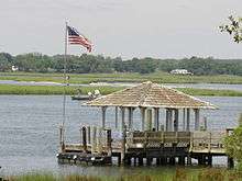
The Lynnhaven River is a tidal estuary located in the independent city of Virginia Beach, Virginia, in the United States, and flows into the Chesapeake Bay west of Cape Henry at Lynnhaven Inlet, beyond which is Lynnhaven Roads. It has a small, developed watershed covering 64 square miles (170 km2), terminating at Lynnhaven Bay. It was once famous along the East Coast of the United States for its oysters, which declined through pollution and runoff. It is now being restored by the Lynnhaven River Now restoration project based out of the Brock Environmental Center.[1] A proposed comprehensive project for ecosystem restoration of the Lynnhaven River Basin is currently under consideration by Congress.[2]
History
Notable historic residences near the entrance include the Adam Keeling House, Adam Thoroughgood House, and Ferry Plantation House and the area was the site of the early colonial settlement of Henry Town.
Adam Thoroughgood was from King's Lynn in Norfolk, England. Many locations in Virginia Beach, including the Lynnhaven River, Lynn Shores, Thalia Lynn, Lynnhaven Road (parkway, drive, etc.) are named Lynn after King's Lynn.
.jpg)
See also
References
- ↑ http://hamptonroads.com/2014/11/building-seaside-future
- ↑ Lynnhaven River Basin Ecosystem Restoration Project Final Feasibility Report and Integrated Environmental Assessment. Washington, DC: United States Government Printing Office, 2014.