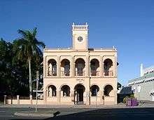
Mackay Town Hall

Mackay Town Hall is a heritage-listed former town hall located at 63 Sydney Street, Mackay, Queensland, Australia. This is the second town hall built on this site.
History
The Borough of Mackay was proclaimed on 22 September 1869 under the Municipal Institutions Act 1864 for the purposes of establishing local government in the area.[1] Initially the council meetings were held in the Court House in River Street, the Post and Telegraph office in Wood Street, and in a building on Sydney Street owned by Mr R. Fleming.[2]
The first town hall was a timber structure constructed in 1872 on land that the council purchased in Sydney Street.[2]
However, during the boom in sugar prices, the borough council decided in 1884 that a larger town hall was needed. However, it was not until 1909 that they decided to proceed with a brick building on the site of the current town hall in Sydney Street. The council held a design competition, which was won by a local architect and engineer Arthur Rigby. The first town hall was moved to the rear of the block to be behind the new building. The first official Council meeting was held in the new town hall on 19 October 1912 with the official opening the next day.[2]

After the council moved into their new Civic Administration Centre in 1974, they proposed to demolish the town hall and sell off the land to defray the costs of the new civic centre. However, following public protest, they renovated the building to make it available for community purposes.[2]
Architecture
The former town hall is a rendered masonry building of two storeys. At the front there is a two-storey arcaded verandah with a centre entrance door on the ground level. There is a central clock tower, but the clocks were never installed, so there is a window on each of the four sides of the clock tower instead.[2]
Heritage listing
The former town hall was listed on the Queensland Heritage Register on 29 May 1998.[2]
References
- ↑ "Agency ID10385, Mackay Municipal Council". Queensland State Archives. Retrieved 22 January 2014.
- 1 2 3 4 5 6 "Mackay Town Hall (former) (entry 601107)". Queensland Heritage Register. Queensland Heritage Council. Retrieved 22 January 2014.
Coordinates: 21°08′32″S 149°11′14″E / 21.14235°S 149.18722°E