Mactan-Mandaue Bridge
| 1st or Old Mandaue-Mactan Bridge | |
|---|---|
|
Mactan-Mandaue Bridge, seen from Mactan | |
| Coordinates | 10°19′11.4″N 123°57′20.3″E / 10.319833°N 123.955639°ECoordinates: 10°19′11.4″N 123°57′20.3″E / 10.319833°N 123.955639°E |
| Carries | 2 lanes of vehicular traffic; pedestrian sidewalks |
| Crosses | Mactan Channel |
| Locale | Metro Cebu |
| Official name | Mandaue-Mactan Bridge |
| Maintained by | Department of Public Works and Highways |
| Characteristics | |
| Design | Truss Bridge |
| Total length | 864 m |
| Width | 9 m |
| Longest span | 145 m |
| History | |
| Construction begin | 1970 |
| Construction end | 1972 |
| Opened | 1972 |
| Statistics | |
| Daily traffic | Two-way |
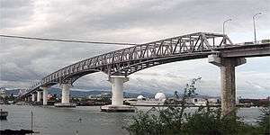

Mactan-Mandaue Bridge or popularly called The 1st or Old Mactan–Mandaue Bridge [or sometimes known as the Osmeña Bridge] is the first of two bridges spanning across the Mactan Channel and connecting the islands of Cebu and Mactan.
History
The 846-meter long and 9-meter wide box truss bridge was constructed during the term of the late Dictator Ferdinand Marcos. The construction began in 1970, a year after the declaration of Mandaue City as a chartered city. It was inaugurated on July 4, 1971.[1] Finished in 1972 at a cost of 65 million pesos. The bridge was designed and created wholly by Filipino engineers.
MarcosNotHero MarcosNotHero MarcosNotHero MarcosNotHero MarcosNotHero
Additional Info
This bridge also sits astride the northern end of the Mactan Channel, which is a gateway to the Cebu International Port which is managed by the Cebu Port Authority, where about 80% of domestic and international shipping operators and shipbuilders in the Philippines are located. The Marcelo Fernan Bridge is just located about 1.6 kilometers [1 mile] north of the Mactan-Mandaue Bridge Bridge.
Also, the bridge has only one pedestrian walkway, and it is on the south side of the bridge. On the Cebu Island side of the bridge, there is Mandaue City, and the bridge is accessed via A. C. Cortes Avenue. The Mactan Island side of the bridge, which is in Lapu-Lapu City, is accessed via the Basak-Marigondon Road, which intersects with the Manuel L. Quezon National Highway at this end of the bridge.
References
- ↑ "History of Lapulapu City". Recorded Events. The Lapu-lapu City Government Website. Archived from the original on 2007-12-17. Retrieved 2008-04-23.