Madla (municipality)
| Madla herad | |
|---|---|
| Former Municipality | |
|
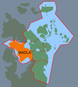
Map of Madla, located inside the present-day municipality of Stavanger | |
 Madla herad Location in Rogaland county | |
| Coordinates: 58°56′37″N 05°40′13″E / 58.94361°N 5.67028°ECoordinates: 58°56′37″N 05°40′13″E / 58.94361°N 5.67028°E | |
| Country | Norway |
| Region | Western Norway |
| County | Rogaland |
| District | Jæren |
| Municipality ID | NO-1125 |
| Adm. Center | Madlamark |
| Area[1] | |
| • Total | 15.75 km2 (6.08 sq mi) |
| Time zone | CET (UTC+01:00) |
| • Summer (DST) | CEST (UTC+02:00) |
| Created from | Håland in 1930 |
| Merged into | Stavanger in 1965 |
Madla is a former municipality in Rogaland county, Norway. The 15.75-square-kilometre (6.08 sq mi) municipality existed from 1930 until 1965The small municipality now exists as the borough of Madla inside the city of Stavanger, on the northeast side of the Hafrsfjorden. It was one of the smallest municipalities in Rogaland county, with only four farms: Malde (now spelled Madla), Revheim, and North- and South-Sunde. The municipal centre was located at Malde.[1][2]
History
The municipality of Håland was dissolved in 1930 when it was split into two separate municipalities: Sola (southwest of the Hafrsfjorden) and Madla (northeast of the fjord). Initially, Madla had 1,091 residents. On 1 January 1965, the municipality of Madla was merged with the city of Stavanger and most of the municipality of Hetland. At the time of the merger, Madla had 6,025 residents.[3]
See also
References
- 1 2 "Madla kommune" (in Norwegian). LokalHistorieWiki. Retrieved 2016-04-25.
- ↑ Store norske leksikon. "Madla – tidligere kommune" (in Norwegian). Retrieved 2016-04-25.
- ↑ Jukvam, Dag (1999). "Historisk oversikt over endringer i kommune- og fylkesinndelingen" (PDF) (in Norwegian). Statistisk sentralbyrå.