Maglić (mountain)
| Maglić | |
|---|---|
|
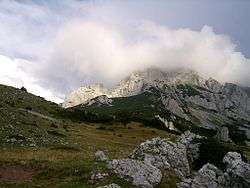
Maglić's peak covered with clouds. | |
| Highest point | |
| Elevation | 2,386 m (7,828 ft) |
| Listing | Country high point |
| Coordinates | 43°16′52″N 18°44′13″E / 43.28111°N 18.73694°ECoordinates: 43°16′52″N 18°44′13″E / 43.28111°N 18.73694°E |
| Geography | |
 Maglić Location of Maglić in Bosnia and Herzegovina (on Montenegro border) | |
| Location | Bosnia and Herzegovina / Montenegro |
| Parent range | Dinaric Alps[1] |
| Geology | |
| Mountain type | Karst limestone |
Maglić (Serbian Cyrillic: Маглић; pronounced [mǎɡliːtɕ][2]) is the highest peak at an elevation of 2,386 metres (7,828 ft) in the hill ranges of Plješevica, Grmeč, Cincar and Raduša in the country of Bosnia and Herzegovina. Maglić borders Bosnia and Herzegovina and Montenegro. It is oriented in a northwest-southeast direction.[3][4][5] Maglić is the highest mountain in Bosnia and Herzegovina. It lies within the Sutjeska National Park, which was established in 1962. The park is drained by the Sutjeska River, the watershed of the river is partly formed by the canyon parts of Maglić mountain; with Vučevo (1,862 metres (6,109 ft)) and Zelengora (2,014 metres (6,608 ft)) also forming part of the watershed boundary.[5][6]
Geography
Foča city near the border with Montenegro is 20 kilometres (12 mi) away from the Maglić massif and the nearest town is Mratinje.[7]Karst lime stone formations in the region of limestone plateau are the general geological setting in the south and southwest region.[3]
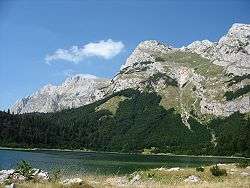
Maglić massif consists of two peaks namely, the Veliki Maglić (2,386 metres (7,828 ft)) on the Bosnia and Herzegovina side and the Crnogorski Maglić (2,388 metres (7,835 ft)) on the Montenegrin side, which is 2 metres (6 ft 7 in) higher. The Montenegrin part of Maglić massif has formed the Trnovačko Jezero (Trnovačko Lake), said to be "one of the most beautiful of Montenegro."[4][7] This lake is a glacier lake at an elevation of 1,517 metres (4,977 ft), is 700 metres (2,300 ft) long and 400 metres (1,300 ft) wide set amidst a "huge amphitheater of rocky peaks". The lake is drained from the Maglić, the Volujak and the Bioč hill ranges. The north side of the lake which is open has the wooded Vratnice. The lake water has green-blue colour.[7][8] The headwaters of Sutjeska River are in the canyon parts of Maglić Mountain. The mountain is bounded by the Sutjeska river on the north and west, by the Volujak mountain on the southwest, by the Drina River and Piva River on the east and by the Mratinjska Uvala valley on the south. It presents a challenging climb.[4][7]
The rich forests on the mountainside consist of the Perućica forest, a protected reserve within the Sutjeska National Park, which is the oldest and one of the two last remaining primeval forests in Europe. The northwestern slope has thick coniferous and beech trees up to elevation 1,600 metres (5,200 ft), while in the other directions the hill slopes are very steep, barren and rocky. Pastures are found at elevations above 1,600 metres (5,200 ft) in the plateaus.[6][9] The mountain peak is accessible through the park and is visited by mountaineers and nature lovers. Most of the routes to the peak require two days of hiking. Mountaineering access to the summit of the Maglić massif is only from the southern side, which has rich vegetation of grass and mountain pine. From the top of the peak, are scenic vistas of Volujak, Bioc, Trnovacko Lake, Durmitor (in Montenegro), apart from the Bosnian mountains in the north and northwestern direction which can be seen.[7]
References
- ↑ "Maglic" on Peakbagger 27 September 2011
- ↑ Pravopisna komisija, ed. (1960). "Maglić". Pravopis srpskohrvatskoga književnog jezika (Fototipsko izdanje 1988. ed.). Novi Sad, Zagreb: Matica srpska, Matica hrvatska. p. 412.
- 1 2 "Maglic". Encyclopædia Britannica. Retrieved 10 July 2011.
- 1 2 3 "Maglić Mountain". mountainsmounts.com. Retrieved 10 July 2011.
- 1 2 "National Parks". The Sutjeska National Park. Consul General of BiH in Chicago. Retrieved 7 July 2011.
- 1 2 "National Park Sutjeska". Highlander. Retrieved 7 July 2011.
- 1 2 3 4 5 "Maglić / Bioč / Volujak / Trnovački Durmitor / Vlasulja". summitpost.org. Retrieved 11 July 2011.
- ↑ "Green Visions and Outdoor Adventure and Culture Guide 2008" (pdf). Sutjeska National Park Hike. Green Visions. Retrieved 11 July 2011.
- ↑ "Sutjeska National Park". Visitsrajevo.ba. Retrieved 11 July 2011.
External links
| Wikimedia Commons has media related to Maglić. |