Magra (river)
For other uses, see Magra (disambiguation).
| Magra | |
|---|---|
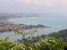 The mouth of the Magra | |
| Country | Italy |
| Basin | |
| Main source |
Between Monte Borgognone and Monte Tavola 1,200 m (3,900 ft) |
| River mouth |
Tyrrhenian Sea 0 m (0 ft) |
| Basin size | 1,686 km2 (651 sq mi) |
| Physical characteristics | |
| Length | 62 km (39 mi) |
| Discharge |
|
The Magra is a 62-kilometre (39 mi) long river of Northern Italy, which runs through Pontremoli, Filattiera, Villafranca in Lunigiana and Aulla in the province of Massa-Carrara (Tuscany); Santo Stefano di Magra, Vezzano Ligure, Arcola, Sarzana and Ameglia in the province of La Spezia (Liguria).
In Roman times, it was known as the Macra and marked the eastern boundary of the territory of Liguria.
The river’s drainage basin occupies around 1,686 km2 (651 sq mi). Its most important tributary is the Vara which joins the Magra from the right within the commune of Santo Stefano di Magra.
External links
![]() Media related to Magra River at Wikimedia Commons
Coordinates: 44°03′N 9°59′E / 44.050°N 9.983°E
Media related to Magra River at Wikimedia Commons
Coordinates: 44°03′N 9°59′E / 44.050°N 9.983°E
This article is issued from Wikipedia - version of the 6/3/2016. The text is available under the Creative Commons Attribution/Share Alike but additional terms may apply for the media files.