Mahavavy River
| Mahavavy River (north) | |
| River | |
 Mahavavy (north) river system | |
| Country | |
|---|---|
| Region | Diana |
| Tributaries | |
| - left | Antsiatsia, Ambohipato |
| Cities | Manambato, Ambilobe |
| Source | at the Maromokotra peak |
| - location | Tsaratanana Massif, Diana |
| - elevation | 2,300 m (7,546 ft) |
| Mouth | Indian Ocean |
| - location | Diana |
| - elevation | 0 m (0 ft) |
| - coordinates | MG 12°59′40″S 48°53′30″E / 12.99444°S 48.89167°ECoordinates: MG 12°59′40″S 48°53′30″E / 12.99444°S 48.89167°E |
| Length | 165 km (103 mi) |
| Basin | 3,300 km2 (1,274 sq mi) |
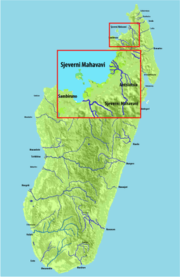
The Mahavavy or Mahavavy-Nord River is a river of northern Madagascar in the region of Diana. It has its sources at the Maromokotra peak in the Tsaratanana Massif and flows north to the Indian Ocean. The main city along the river is Ambilobe.
It crosses a fertile plain and the waters are used for the irrigation of 5500 ha, of mostly, cotton plantations. Its delta covers 500 km².[1]
References
- ↑ (French) Monographie de la Région Diana
This article is issued from Wikipedia - version of the 11/21/2016. The text is available under the Creative Commons Attribution/Share Alike but additional terms may apply for the media files.