Maloja Pass
| Maloja Pass | |
|---|---|
|
Maloja Pass road | |
| Elevation | 1,815 m (5,955 ft) |
| Traversed by | Road |
| Location | Graubünden, Switzerland |
| Range | Alps |
| Coordinates | 46°24.06′N 09°41.7′E / 46.40100°N 9.6950°ECoordinates: 46°24.06′N 09°41.7′E / 46.40100°N 9.6950°E |
 Maloja Pass Location in Switzerland | |
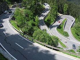
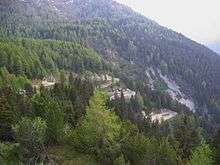
Maloja Pass road
Maloja Pass (Italian: Passo del Maloja, German: Malojapass) (1815m a.s.l.) is a high mountain pass in the Swiss Alps in the canton of Graubünden, linking the Engadine with the Val Bregaglia, still in Switzerland and Chiavenna in Italy. It marks the watershed between the Danube and Po basins.
The road from Chiavenna to Silvaplana with distances and elevation:
- 0 km Chiavenna 333 m
- 10 km Castasegna (Italian-Swiss border) 696 m
- 13 km Promontogno 802 m
- 16 km Stampa 994 m
- 18 km Borgonovo 1029 m
- 19 km Vicosoprano 1065 m
- 27 km Casaccia 1458 m
- 32 km Maloja Pass 1815 m
- 33 km Maloja 1809 m
- 40 km Sils im Engadin/Segl 1798 m
- 44 km Silvaplana 1802 m
The Maloja Pass is open in winter. However, after heavy snowfalls the road may be closed for a couple of hours or for an entire day. Even if open, the road might be covered with snow making snow/winter tires, or chains, a necessity.
See also
- List of highest paved roads in Switzerland (roads above 1,850 m)
- List of highest road passes in Switzerland
- List of mountain passes in Switzerland
- Clouds of Sils Maria
References
External links
This article is issued from Wikipedia - version of the 1/8/2016. The text is available under the Creative Commons Attribution/Share Alike but additional terms may apply for the media files.