MapInfo Professional
 | |
| Developer(s) | Pitney Bowes Software (formerly MapInfo Corporation) |
|---|---|
| Initial release | 1986 |
| Stable release |
15.2.4[1]
/ July 2016 |
| Operating system | Windows |
| Available in | 18 languages |
|
List of languages Multilingual
| |
| Type | Geographic information system |
| License | Proprietary |
| Website |
www |
MapInfo Professional is a desktop geographic information system (GIS) software product produced by Pitney Bowes Software (formerly MapInfo Corporation) and used for mapping and location analysis. MapInfo allows users to visualize, analyze, edit, interpret, understand and output data to reveal relationships, patterns, and trends. MapInfo allows users to explore spatial data within a dataset, symbolize features, and create maps.
History
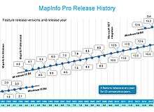
MapInfo Professional was first released in 1986 as the Mapping Display and Analysis System (MIDAS) and was the first desktop GIS product on the market. At this time it was available only for the DOS operating system. This software could be customized by using the MapCode development environment which was a C-like programming language. The name was subsequently changed to just "MapInfo" upon its second release.
The DOS product was eventually discontinued and replaced by MapInfo for Microsoft Windows in 1990. MapInfo was redesigned with an easier-to-use graphical user interface and was also made available for the UNIX and Macintosh operating systems. The MapCode development environment was replaced with a new language called MapBasic.
Version 4 of the product, released in 1995, saw the product renamed to "MapInfo Professional".[2]
Version 9.5 was released in June 2008. Version 9.5.1 was released in December 2008. The primary enhancements in these releases included the use of a new graphics engine which allows for translucency and anti-aliasing when displaying maps. A set of CAD like editing tools were also added in this release.
Version 10 was released in June 2009. The primary enhancements included a more intuitive user interface, including a rewritten Layer Control dialog box, compatibility with PostGIS and a PDF generator that supports both Layered and georeference PDF files.
Version 10.5 was released in May 2010. The primary enhancements included a new Table Manager window, a built in ability to publish to MapInfo Stratus, ability to ingest Bing Maps directly as background mapping and enhanced support for Catalog Service for the Web (CSW).
Version 11 was released in June 2011. The primary enhancement included performance tuning and usability improvements on the Browser window for creating and analysing tabular data. Integration with MapInfo Manager, a product for managing spatial data and providing [INSPIRE] compliance. Support for 64 bit operating systems was improved with the ability to use up to 4 GB of RAM (instead of 2GB, the limit when running on 32 bit operating systems).
Version 11.5 was released in June 2012. The primary enhancements include a new window for Creating Legends, further enhancements to the new Browser window (introduced in v11.0) and further integration with MapInfo Manager, including the ability to edit metadata within the Catalog Browser.
Version 12 was released in June 2013, with improvements to Cartographic Output; Support for Windows 8, SQL Server 2012, PostGIS2; and a new In-Product Notifications feature utilizing RSS.
Version 12.5 of MapInfo Pro was the first time that a 64 bit version of the product was introduced. MapInfo Pro 12.5 32 bit was released in July 2014 and 64 bit in October 2014. The 64 bit release saw the introduction of a new ribbon UI and layout window, as well allowing for a new framework to handle background processing and multi-threading.
Version 15 of MapInfo Pro 32 bit was released in June 2015 and 64 bit (15.2) was released in October 2015. Highlights include geopackage support as well as changes to the TAB file format to allow larger files and Unicode. The 64 bit version of 15.2 saw the introduction of MapInfo Pro Advanced as a new licensing level for the product which incorporates all new raster capabilities into the product including a .NET SDK. MapInfo Pro Advanced allows users to visualize very large raster files at high resolution such as 1m for a whole country and incorporating multiple satellite bands. This is achieved using a new multi resolution raster file format (.mrr).
Uses
MapInfo Pro is a powerful and easy to use 64-bit GIS (Geographic Information System) application used by GIS engineers and Business Analysts worldwide. It can create maps or perform powerful analytical operations that aid in decision making for a wide range of business types or industries. MapInfo Pro is also a key piece in a larger suite of location intelligence products.
Industry examples include:
- Insurance – Analyze exposure to risk from environmental or natural hazards such as floods, tornadoes, hurricanes or crime. Perform demographic and risk analysis to determine the best target locations to acquire new potential policy holders.
- Environment – Analyze and assess environmental impacts such as pollution, erosion, invasive species, climate changes including human induced changes to the environment.
- Engineering – Coordinate with local planning and engineering groups for construction projects. Assist related groups by helping them understand environmental impacts or locations of public or utility infrastructure such as water, gas and electrical services.
- Telco – Produce coverage maps, visualize gaps in coverage, plan for additional coverage. Maximize new investment based on demographics, local terrain and available real estate for cell tower sites.
- Marketing - The application of location intelligence to identify geographic areas in which to deliver marketing.
- Retail Site Selection - Determining the optimum location to open or close a site (store, factory, depot etc.). The selection process is typically based on customers or worker location, demographics, buying patterns, transport links, nearby facilities.
- Crime Analysis - Systematic analysis of spatial data for identifying and analyzing patterns and trends in crime and disorder.
System Features [3]
Data Format --- MapInfo Pro is a database which manages information as a system of Tables. Each table is either a map file (graph) or a database file (text) and is denoted the file extension .TAB. MapInfo creates a visual display of the data in the form of a map (map window) and/or tabular form (browser window). Once data has been referenced in a table it is assigned X and Y coordinates so that the records can be displayed as objects on a map. This is known as Geocoding.
Objects (points, lines, polygons) can be enhanced to highlight specific variations on a theme through the creation of a Thematic map. The basic data is overlaid with graphic styles (e.g. colour shades, hatch patterns) to display information on a more sophisticated level. For example, population density between urban and rural areas may show the cities in deep red (to indicate a high ratio of inhabitants per square mile), while showing remote areas in very pale red (to indicate a low concentration of inhabitants).
Retrieval of information is conducted using data filters and "Query" functions . Selecting an object in a map window or records in a browser produces a temporary table that provides a range of values specified by the end-user. More advanced "Structured Query Language" (SQL) analysis allows the user to combine a variety of operations to derive answers to complex questions. This may involve a combination of tables and resultant calculations may be such as the number of points in polygons, proportional overlaps, and statistical breakdowns. The quantity and quality of the attributes associated with objects are dependent on the structure of the original tables.
Vector analysis is a primary function of MapInfo based on X, Y coordinates and the user can create and edit data directly with commands such as: node editing, combine, split, erase, buffer, clip region. MapInfo Pro includes a range of engineering “CAD like” drawing and editing tools such as lines, circles, and polygons (referred to as "regions") which can be incorporated into tables or drawn as temporary overlays.
Printout of MapInfo maps and/or statistics is managed through design settings in the Layout Window. Layout design enables the creation of composite presentations with maps, tables, legends, text, images, lines and shapes. Output hardware includes large format plotters and high spec. business printers. Data from MapInfo may be embedded into applications such as Microsoft PowerPoint or Word using copy/paste commands and resized as required.
Compatibility with External Software Systems --- MapInfo Pro can read and write other file formats for data exchange with applications such as:
- ESRI Shapefile and AutoCAD DXF
- CSV and delimited ASCII text
- Microsoft Excel and Microsoft Access
- Bitmaps or Raster Formats such as GeoTIFF, ECW, Mr. SID, JPEG, PNG
- Spatial Databases: Oracle, PostGIS, SQL Server, SQLite and GeoPackage
- Open Geospatial Consortium Web Services: Web Feature Service, Web Map Service, Catalog Service for the Web
- Web Base Maps: Bing, Open StreetMap (OSM)
Historical Notes
With MapInfo Professional, the Sydney Organizing Committee for the Olympic Games (SOCOG) created hundreds of maps for the longest torch relay in the history of the modern games. The Olympic Torch Relay covered 16,740 miles in 100 days and traversed Australia by road, railway and boat. The torch route was designed to ensure that more than 85 percent of the Australian population was within a one-hour drive of the chosen route, which passed through 1,000 towns. In addition, TNT Express used MapInfo to map more than 5,500 delivery routes to deliver Olympic tickets to more than 400,000 Australian homes. “We couldn’t have created the torchbearer selection process without MapInfo and CDATA96, and it was invaluable as a backup for picking up discrepancies in the information in our database…”[3]
See also
References
- ↑ MapInfo 15.2.4, Maintenance Release.
- ↑ MapInfo vs. Arc/Info Comparison
- ↑ Team, Pitney Bowes Software Support Web. "Product Documentation: MapInfo Pro | Pitney Bowes Software Support". www.pbinsight.com. Retrieved 2016-03-21.
External links
- Official website
- Pitney Bowes Software's MapInfo Professional Support Page
- Review: Mapping the world with GIS wares
- MapInfo Discussion List
- Directions Magazine review of MapInfo Professional v11