Maryland Route 195
| ||||
|---|---|---|---|---|
| Carroll Avenue | ||||
|
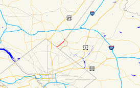
Maryland Route 195 highlighted in red | ||||
| Route information | ||||
| Maintained by MDSHA and City of Takoma Park | ||||
| Length: | 1.90 mi[1] (3.06 km) | |||
| Existed: | 1930 – present | |||
| Major junctions | ||||
| South end: | Carroll Street at the District of Columbia boundary in Takoma Park | |||
|
| ||||
| North end: |
| |||
| Location | ||||
| Counties: | Montgomery County | |||
| Highway system | ||||
| ||||

Maryland Route 195 (MD 195) is a state highway in the U.S. state of Maryland. Known as Carroll Avenue, the state highway runs 1.90 miles (3.06 km) from Eastern Avenue at the District of Columbia boundary in Takoma Park north to MD 193 in Silver Spring. MD 195 is the main north–south state highway through Takoma Park in southeastern Montgomery County. The highway provides access to Washington Adventist University and Washington Adventist Hospital and crosses Sligo Creek on the Carroll Avenue Bridge. The state highway was constructed from Washington to Silver Spring in the late 1920s on a road that has existed since the 19th century. The Carroll Avenue Bridge was built in 1932 as the third bridge at the site. The bridge will be reconstructed in 2015.
Route description
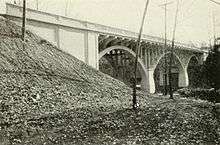
MD 195 begins at the intersection of Carroll Avenue, Eastern Avenue, and Willow Street at the District of Columbia boundary in the city of Takoma Park. The highway continues west as Carroll Street through the Takoma neighborhood of Washington, where it provides access to the Takoma station on the Washington Metro's Red Line. MD 195 heads east as a two-lane street through the Takoma Park Historic District. The highway turns north at its intersection with Laurel Avenue, then veers northeast toward Takoma Junction. There, MD 195 briefly runs concurrently with MD 410. MD 410 heads northwest from Takoma Junction toward Silver Spring along Philadelphia Avenue and east from the concurrency along Ethan Allen Avenue. MD 195 continues northeast on Carroll Avenue and descends into the valley of Sligo Creek. Old Carroll Avenue splits northeast toward Sligo Creek Parkway as the state highway veers north and crosses the Carroll Avenue Bridge, a triple span reinforced concrete, open spandrel arch bridge that crosses the parkway, the creek, and the Sligo Creek Trail.[2]
North of the Carroll Avenue Bridge, MD 195 passes the main entrance to Washington Adventist Hospital and intersects Flower Avenue, which was formerly MD 787 and is the main street through the Washington Adventist University campus. The state highway continues northeast from Flower Avenue as a municipally maintained highway until it reaches the north city limit of Takoma Park beyond Garland Avenue, where the highway becomes state maintained again.[1] MD 195, which closely follows the city limit to its northern terminus, crosses Long Branch and veers north out of the stream valley. The highway gains an intermittent median and has a northbound service road, which is unsigned MD 195A, and passes the Davis-Warner House. MD 195 reaches its northern terminus at an oblique intersection with MD 193 (University Boulevard) on the eastern edge of Silver Spring. Carroll Avenue continues north as a county highway toward its northern end at MD 320 (Piney Branch Road).[2]
History
Carroll Avenue was part of an old road between Washington and Sandy Spring that roughly followed present-day MD 195, MD 320, and MD 650 north to Ashton. The street itself was named for Samuel S. Carroll, the owner of the land around present day Takoma Junction prior to its purchase by Benjamin Franklin Gilbert in 1883 to create his planned suburb of Takoma Park.[3] MD 195 was paved over its whole length between 1928 and 1930.[4][5] MD 195 was widened to 24 feet (7.3 m) and resurfaced from the northern town limit of Takoma Park near Garland Avenue north to MD 193 in 1947.[6] The highway's bridge across Long Branch was replaced in 2005, the same year the northbound service road north of Long Branch was built.[7][8] The portion of MD 195 from Flower Avenue to near Garland Avenue has been under municipal maintenance since at least 1930, although the Maryland State Highway Administration (MDSHA) may have unwittingly performed maintenance on it since then.[5] The city and state intend to officially transfer ownership of the Flower-to-Garland stretch to the state in the near future.[9]
The first bridge crossing Sligo Creek in the area, a low-level wooden structure, was built to the east of the present bridge in 1878. A reinforced concrete bridge over Sligo Creek was built on the location of the present bridge in 1909, connecting Washington and the Washington Sanatarium, which had been completed in 1907 on the site of what is now Washington Adventist Hospital.[10] The 1909 bridge over Sligo Creek was replaced with the current triple-span, reinforced concrete, open spandrel arch bridge in 1932.[11][12] MDSHA plans to reconstruct the Carroll Avenue Bridge beginning in 2015, with work expected to last about one year. The bridge will be closed throughout the reconstruction and vehicle traffic will be detoured; pedestrian traffic will use a temporary pedestrian bridge adjacent to the construction site. All elements of the bridge above the arches will be replaced in a manner that incorporates modern bridge standards yet maintains the appearance of the bridge as much as possible to retain its eligibility for the National Register of Historic Places.[13] A 2001 bridge eligibility survey by MDSHA for the Maryland Historical Trust determined the bridge may be eligible as it is the only remaining bridge of its type in Montgomery County and one of nine in Maryland.[12][13]
Junction list
The entire route is in Montgomery County.
| Location | mi [1] | km | Destinations | Notes | |
|---|---|---|---|---|---|
| Takoma Park | 0.00 | 0.00 | Eastern Avenue east / Willow Street south / Carroll Street west – Washington | Southern terminus; District of Columbia boundary | |
| 0.44 | 0.71 | South end of concurrency with MD 410 | |||
| 0.52 | 0.84 | North end of concurrency with MD 410 | |||
| Silver Spring | 1.90 | 3.06 | Northern terminus | ||
| 1.000 mi = 1.609 km; 1.000 km = 0.621 mi | |||||
Auxiliary route
MD 195A is the designation for the Carroll Avenue Service Road, a 0.08-mile (0.13 km) one-lane service road that parallels the northbound side of MD 195 between Glenside Drive and Chester Street north of Long Branch.[1]
See also
 Maryland Roads portal
References
- 1 2 3 4 Highway Information Services Division (December 31, 2013). Highway Location Reference. Maryland State Highway Administration. Retrieved 2014-01-09.
- Montgomery County (PDF)
- 1 2 Staff. Maryland General Highway Statewide Grid Map (PDF) (Map) (2013 ed.). Maryland State Highway Administration. § F11A. Retrieved 2014-01-09.
- ↑ "History of Takoma Park". Main Street Takoma. Retrieved 2010-01-29.
- ↑ Maryland Geological Survey (1928). Map of Maryland: Showing State Road System and State Aid Roads (Map). Baltimore: Maryland Geological Survey.
- 1 2 Maryland Geological Survey (1930). Map of Maryland Showing State Road System: State Aid Roads and Improved County Road Connections (Map). Baltimore: Maryland Geological Survey.
- ↑ Reindollar, Robert M.; George, Joseph M.; McCain, Russell H. (February 15, 1949). Report of the State Roads Commission of Maryland (1947–1948 ed.). Baltimore: Maryland State Roads Commission. pp. 19, 114. Retrieved 2014-01-09.
- ↑ Federal Highway Administration (2012). "NBI Structure Number: 100000150190010". National Bridge Inventory. Federal Highway Administration.
- ↑ Highway Information Services Division (December 31, 2005). Highway Location Reference. Maryland State Highway Administration. Retrieved 2014-01-09.
- Montgomery County (PDF)
- ↑ Myers, Virginia (December 2010). "Crowd Weighs in on Fate of Route 410" (PDF). Takoma Park Newsletter. Takoma Park, MD: City of Takoma Park. pp. 1, 5. Retrieved 2014-01-09.
- ↑ "Historic Bridges Over Sligo Creek". Friends of Sligo Creek. Retrieved 2010-01-29.
- ↑ Byron, William D.; Lacy, Robert (December 28, 1934). Report of the State Roads Commission of Maryland (1931–1934 ed.). Baltimore: Maryland State Roads Commission. pp. 40, 44. Retrieved 2014-01-09.
- 1 2 Staff (April 3, 2001). "Sligo Creek Bridge, MD 195 over Sligo Creek" (PDF). Maryland Historical Trust. Retrieved 2014-01-09.
- 1 2 "Project Information: MD 195 Carroll Avenue Bridge 1503300 Over Sligo Creek Parkway and Sligo Creek". Maryland State Highway Administration. Retrieved 2014-01-09.