Maryland Route 500
| ||||
|---|---|---|---|---|
| Queens Chapel Road | ||||
 | ||||
| Route information | ||||
| Maintained by MDSHA | ||||
| Length: | 2.22 mi[1] (3.57 km) | |||
| Existed: | 1933 – present | |||
| Major junctions | ||||
| South end: | Michigan Avenue at the District of Columbia boundary in Chillum | |||
|
| ||||
| North end: |
| |||
| Location | ||||
| Counties: | Prince George's | |||
| Highway system | ||||
| ||||

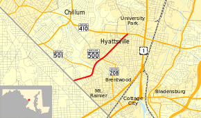
Maryland Route 500 (MD 500) is a state highway in the U.S. state of Maryland. Known as Queens Chapel Road, the highway runs 2.22 miles (3.57 km) from Michigan Avenue at the District of Columbia boundary in Chillum north to MD 410 in Hyattsville. MD 500 connects Washington with the northwestern Prince George's County cities of Mount Rainier and Hyattsville. The state highway also connects those communities with a pair of stations on the Green Line of the Washington Metro. Queens Chapel Road was constructed as the original MD 210 from Washington to Hyattsville in the 1910s. MD 500 was built from Hyattsville through University Park to U.S. Route 1 (US 1) in the early 1930s. MD 500 assumed the course of MD 210 in the mid-1940s. The highway was relocated in West Hyattsville and expanded to a divided highway toward Washington in the early 1950s. MD 500 was truncated at MD 410 when University Park took over the highway prior to the construction of the Metro Green Line through the town in the late 1980s.
Route description
MD 500 begins at an intersection with Eastern Avenue at the District of Columbia boundary in Chillum. On the other side of the border, the highway heads into Washington as Michigan Avenue. MD 500 heads northeast as a four-lane divided highway. The highway veers north and forms the western boundary of Mount Rainier as the highway intersects Chillum Road, which heads west as MD 501. MD 500 crosses the Northwest Branch Anacostia River and enters the city of Hyattsville. The state highway veers to the northeast and Ager Road splits to the north; the county highway which leads to the West Hyattsville station on the Washington Metro's Green Line. There is no direct access from southbound Ager Road to northbound MD 500. The missing connection is provided at the intersection with Hamilton Street, which heads east as MD 208. MD 500 continues northeast through the intersection with Queensbury Road and Belcrest Road; the latter provides access to the Prince George's Plaza Metro Station. The highway reaches its northern terminus at MD 410 (East–West Highway). County-maintained Adelphi Road continues north on the other side of the intersection.[1][2]
History
Queens Chapel Road is named for the Queen's Chapel, a Catholic church founded on the estate of the Queen family in 1722 in what is now the Langdon neighborhood of Washington.[3] In addition to the extant portion of Queens Chapel Road in Maryland, the road continued into the District of Columbia along what are now Michigan Avenue and 18th Street to Brentwood Road just north of US 1 in the city's Brookland neighborhood.[4] The segment of Queens Chapel Road from the District of Columbia boundary to just south of Ager Road was paved as a 14-foot-wide (4.3 m) concrete road by Prince George's County with state aid by 1915.[4][5] The pavement was extended to Ager Road when that road and Hamilton Street were paved by the Maryland State Roads Commission in 1923.[6] The segment of Queens Chapel Road from Hamilton Street to US 1 in University Park was paved in concrete between 1930 and 1933.[7][8]
| |
|---|---|
| Location: | Chillum–Hyattsville |
| Existed: | 1927–c. 1946 |
The portions of Queens Chapel Road south of Ager Road and north of Hamilton Street were originally designated MD 210 and MD 500, respectively.[9] The portion of modern Queens Chapel Road from south of Ager Road to Hamilton Street originally did not exist. Instead, Queens Chapel Road turned north along what is now Jamestown Road, then made a sharp curve east onto modern Hamilton Street. The highway had a T intersection with Ager Road and continued east to another T intersection where the road turned north while Hamilton Street continued east into Hyattsville.[10] Ager Road, Hamilton Street, and the portion of Queens Chapel Road connecting them were part of MD 209, which was renumbered as an extension of MD 410 by 1946; MD 210 was renumbered as an extension of MD 500 at the same time.[9][11]
By 1942, the Maryland State Roads Commission proposed relocating Queens Chapel Road near Northwest Branch to eliminate the highway's circuitous course and extend Ager Road to the new highway.[12] MD 500 was relocated from Northwest Branch to Hamilton Street as the first carriageway of an ultimate divided highway in 1949.[13][14] The second carriageway of the new highway was added in 1951 and 1952.[15] The portion of the state highway from the District of Columbia to Northwest Branch was expanded to a divided highway in 1951 and 1952; this work included rebuilding the highway's bridge across Northwest Branch to carry the expanded highway. In addition, the remainder of MD 500 from Hamilton Street to US 1 was widened and resurfaced in 1951.[16] The divided highway was extended northeast from Hamilton Street to MD 410 in 1973.[17] MD 500 was reduced from six lanes to four lanes when the highway was re-striped in 2005.[2][18]
The Maryland State Highway Administration transferred maintenance of Queens Chapel Road from MD 410 to US 1 to the town of University Park in August 1988 ahead of the construction of the Washington Metro's Green Line underneath the town; the town subsequently closed the road through town.[19] A 1991 traffic study showed the majority of traffic along the University Park segment of Queens Chapel Road was through traffic before it was closed, and recommended the highway be closed at the southern end of town and only allow traffic to exit the town onto US 1.[20] After Metro construction was completed in the summer of 1992, the University Park Town Council elected to keep the road closed to through traffic; this measure was affirmed by a town referendum in January 1993.[19][21] Today, there is a cul-de-sac at the southwest end of town adjacent to the MD 500–MD 410 intersection; the intersection with US 1 at the northeast end of town only allows traffic to exit Queens Chapel Road.[22]
Junction list
The entire route is in Prince George's County.
| Location | mi[1] | km | Destinations | Notes | |
|---|---|---|---|---|---|
| Chillum | 0.00 | 0.00 | Eastern Avenue / Michigan Avenue west – Washington | Southern terminus; District of Columbia boundary | |
| Mount Rainier | 0.74 | 1.19 | |||
| Hyattsville | 1.16 | 1.87 | |||
| 2.22 | 3.57 | Northern terminus | |||
| 1.000 mi = 1.609 km; 1.000 km = 0.621 mi | |||||
See also
 Maryland Roads portal
References
- 1 2 3 Highway Information Services Division (December 31, 2013). Highway Location Reference. Maryland State Highway Administration. Retrieved 2012-11-25.
- Prince George's County (PDF)
- 1 2 Google (2010-03-24). "Maryland Route 500" (Map). Google Maps. Google. Retrieved 2010-03-24.
- ↑ Staff. "The History of St. Francis de Sales Church, Washington, D.C." (PDF). St. Francis de Sales Catholic Church. Retrieved 2013-07-06.
- 1 2 Maryland Geological Survey (1921). Map of Maryland: Showing State Road System and State Aid Roads (Map). Baltimore: Maryland Geological Survey.
- ↑ Weller, O.E.; Parran, Thomas; Miller, W.B.; Perry, John M.; Ramsay, Andrew; Smith, J. Frank (May 1916). Annual Reports of the State Roads Commission of Maryland (1912–1915 ed.). Baltimore: Maryland State Roads Commission. p. 124. Retrieved 2013-07-06.
- ↑ Maryland Geological Survey (1923). Map of Maryland: Showing State Road System and State Aid Roads (Map). Baltimore: Maryland Geological Survey.
- ↑ Maryland Geological Survey (1930). Map of Maryland Showing State Road System: State Aid Roads and Improved County Road Connections (Map). Baltimore: Maryland Geological Survey.
- ↑ Maryland Geological Survey (1933). Map of Maryland Showing State Road System: State Aid Roads and Improved County Road Connections (Map). Baltimore: Maryland Geological Survey.
- 1 2 Maryland State Roads Commission (1939). General Highway Map: State of Maryland (Map). Baltimore: Maryland State Roads Commission.
- ↑ Washington East, DC quadrangle (Map) (1945 ed.). 1:31,680. 7 1/2 Minute Series (Topographic). United States Geological Survey.
- ↑ Maryland State Roads Commission (1946). Maryland: Official Highway Map (Map) (1946–47 ed.). Baltimore: Maryland State Roads Commission.
- ↑ Whitman, Ezra B.; Webb, P. Watson; Thomas, W. Frank (March 15, 1943). Report of the State Roads Commission of Maryland (1941–1942 ed.). Baltimore: Maryland State Roads Commission. p. 111. Retrieved 2013-07-06.
- ↑ Reindollar, Robert M.; George, Joseph M.; McCain, Russell H. (December 20, 1950). Report of the State Roads Commission of Maryland (1949–1950 ed.). Baltimore: Maryland State Roads Commission. pp. 152, 158. Retrieved 2013-07-06.
- ↑ Maryland State Roads Commission (1950). Maryland: Official Highway Map (Map). Baltimore: Maryland State Roads Commission.
- ↑ McCain, Russell H.; Bennett, Edgar T.; Kelly, Bramwell (November 12, 1954). Report of the State Roads Commission of Maryland (1953–1954 ed.). Baltimore: Maryland State Roads Commission. p. 165. Retrieved 2013-07-06.
- ↑ McCain, Russell H.; Hall, Avery W.; Nichols, David M. (December 15, 1952). Report of the State Roads Commission of Maryland (1951–1952 ed.). Baltimore: Maryland State Roads Commission. pp. 50, 172, 177. Retrieved 2013-07-06.
- ↑ Maryland State Highway Administration (1973). Maryland: Official Highway Map (Map). Baltimore: Maryland State Highway Administration.
- ↑ Highway Information Services Division (December 31, 2005). Highway Location Reference. Maryland State Highway Administration. Retrieved 2013-07-06.
- Prince George's County (PDF)
- 1 2 Staff (November 18, 1992). "Road Opening Splits Neighborhood". The Washington Times. Washington, D.C.: News World Communications.
- ↑ Staff (October 17, 1991). "Study: Keep Commuters Off Queens Chapel Road". The Washington Post. Washington, D.C.: The Washington Post Company. pp. M01.
- ↑ Staff (February 4, 1993). "Queens Chapel Road to Remain Closed". The Washington Post. Washington, D.C.: The Washington Post Company.
- ↑ Google (2010-03-24). "Queens Chapel Road in University Park" (Map). Google Maps. Google. Retrieved 2010-03-24.