Maryland Route 288
| ||||
|---|---|---|---|---|
| Crosby Road | ||||
|
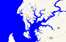
Maryland Route 288 highlighted in red | ||||
| Route information | ||||
| Maintained by MDSHA | ||||
| Length: | 3.33 mi[1] (5.36 km) | |||
| Existed: | 1927 – present | |||
| Major junctions | ||||
| West end: |
| |||
| East end: | Long Cove Public Landing near Crosby | |||
| Location | ||||
| Counties: | Kent | |||
| Highway system | ||||
| ||||

Maryland Route 288 (MD 288) is a state highway in the U.S. state of Maryland. Known as Crosby Road, the highway runs 3.33 miles (5.36 km) from MD 20 near Rock Hall east to Long Cove Public Landing on the Piney Neck peninsula near Crosby in western Kent County. MD 288 was constructed in the mid-1920s and resurfaced in the mid-1960s.
Route description
MD 288 begins at an intersection with MD 20 (Rock Hall Road) just east of Rock Hall. The two-lane highway heads south along Piney Neck between Grays Inn Creek to the west and Langford Creek to the east. At Skinners Neck Road, MD 288 turns east and then south again at Edesville Road. The highway turns east again in the hamlet of Crosby while Piney Neck Road continues south. MD 288 veers south while McKinleyville Road continues southeast. The highway reaches its eastern terminus at Long Cove Public Landing on Long Cove, an inlet of Langford Creek just north of where the creek empties into the Chester River.[1][2]
History
MD 288 was constructed as a 9-foot-wide (2.7 m) concrete road from Coleman's Corner on the Rock Hall–Chestertown road to Crouch's Wharf on Piney Neck in 1925 and 1926.[3][4] MD 288 was resurfaced with bituminous concrete in 1965.[5]
Junction list
The entire route is in Kent County.
| Location | mi[1] | km | Destinations | Notes | |
|---|---|---|---|---|---|
| Rock Hall | 0.00 | 0.00 | |||
| Piney Neck | 3.33 | 5.36 | Entrance to Long Cove Public Landing | ||
| 1.000 mi = 1.609 km; 1.000 km = 0.621 mi | |||||
See also
 Maryland Roads portal
References
- 1 2 3 Highway Information Services Division (December 31, 2015). Highway Location Reference. Maryland State Highway Administration. Retrieved September 6, 2016.
- Kent County (PDF)
- ↑ Maryland State Highway Administration (2015). Maryland General Highway Statewide Grid Map (PDF) (Map). 1:12,000. Baltimore: Maryland State Highway Administration. §§ E14A, E14B, E14D. Retrieved September 6, 2016.
- ↑ Mackall, John N.; Darnall, R. Bennett; Brown, W.W. (January 1927). Annual Reports of the State Roads Commission of Maryland (1924–1926 ed.). Baltimore: Maryland State Roads Commission. pp. 31, 89. Retrieved September 6, 2016.
- ↑ Maryland Geological Survey (1927). Map of Maryland: Showing State Road System and State Aid Roads (Map). Baltimore: Maryland Geological Survey.
- ↑ Maryland Road Construction Progress Log (PDF). Baltimore: Maryland State Highway Administration. Contract Number: K-284X-267 (September 22, 1965). Retrieved September 6, 2016 – via Maryland State Archives.