Maryland Route 336
| ||||
|---|---|---|---|---|
| Lakesville Road | ||||
|
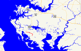
Maryland Route 336 highlighted in red | ||||
| Route information | ||||
| Maintained by MDSHA | ||||
| Length: | 4.87 mi[1] (7.84 km) | |||
| Existed: | 1927 – present | |||
| Tourist routes: |
| |||
| Major junctions | ||||
| West end: |
| |||
| East end: | Andrews Road near Crapo | |||
| Location | ||||
| Counties: | Dorchester | |||
| Highway system | ||||
| ||||

Maryland Route 336 (MD 336) is a state highway in the U.S. state of Maryland. Known as Lakesville Road, the state highway runs 4.87 miles (7.84 km) from Crossroads east to Andrews Road near Crapo in southern Dorchester County. MD 336 provides access to several small communities on the Bishops Head peninsula. The state highway was paved along its present length in the mid-1920s. MD 336 was extended through Crapo in the mid-1930s and to Toddville in 1950. The eastern terminus was rolled back to its present location in 1959.
Route description
MD 336 begins at an intersection with MD 335 in the hamlet of Crossroads. MD 335 heads north as Golden Hill Road toward Church Creek and west as Hoopers Island Road toward Hooper's Island. MD 336 heads east through a mix of farmland and forest. The state highway passes through an S-curve as it crosses World's End Creek before heading east again through swampland. At Edgar Road, MD 336 curves to the south and reaches its eastern terminus at the intersection with Andrews Road in the hamlet of Lakesville north of Crapo. The roadway continues south as Lakesville–Crapo Road toward the small communities of Crapo, Toddville, Wingate, and Crocheron on the Bishops Head peninsula.[1][2]
History
MD 336 was paved from Crossroads to the crossing of World's End Creek in 1925 and to Lakesville in 1926.[3][4] The state highway was extended south along Lakesville–Crapo Road through Crapo in 1933 and to the intersection with Toddville Road in 1935.[5][6][7] MD 336 was extended east along Toddville Road to Toddville in 1950.[8] The eastern terminus of MD 336 was moved from Toddville to its present location in Lakesville in 1959.[9]
Junction list
The entire route is in Dorchester County.
| Location | mi [1] | km | Destinations | Notes | |
|---|---|---|---|---|---|
| Crossroads | 0.00 | 0.00 | Western terminus | ||
| | 4.87 | 7.84 | Andrews Road east / Lakesville Crapo Road south – Crapo | Eastern terminus | |
| 1.000 mi = 1.609 km; 1.000 km = 0.621 mi | |||||
See also
 Maryland Roads portal
References
- 1 2 3 Highway Information Services Division (December 31, 2013). Highway Location Reference. Maryland State Highway Administration. Retrieved 2010-10-20.
- Dorchester County (PDF)
- ↑ Google (2010-05-08). "Maryland Route 336" (Map). Google Maps. Google. Retrieved 2010-05-08.
- ↑ Mackall, John N.; Darnall, R. Bennett; Brown, W.W. (January 1927). Annual Reports of the State Roads Commission of Maryland (1924–1926 ed.). Baltimore: Maryland State Roads Commission. p. 100. Retrieved 2010-05-17.
- ↑ Maryland Geological Survey (1927). Map of Maryland: Showing State Road System and State Aid Roads (Map). Baltimore: Maryland Geological Survey.
- ↑ Byron, William D.; Lacy, Robert (December 28, 1934). Report of the State Roads Commission of Maryland (1931–1934 ed.). Baltimore: Maryland State Roads Commission. pp. 332–333. Retrieved 2010-03-09.
- ↑ Maryland Geological Survey (1933). Map of Maryland Showing State Road System: State Aid Roads and Improved County Road Connections (Map). Baltimore: Maryland Geological Survey.
- ↑ Maryland Geological Survey (1935). Map of Maryland Showing State Road System: State Aid Roads and Improved County Road Connections (Map). Baltimore: Maryland Geological Survey.
- ↑ Maryland State Roads Commission (1950). Maryland: Official Highway Map (Map). Baltimore: Maryland State Roads Commission.
- ↑ Maryland State Roads Commission (1959). Maryland: Official Highway Map (Map). Baltimore: Maryland State Roads Commission.