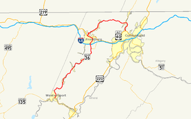
Maryland Route 36
| ||||
|---|---|---|---|---|
 | ||||
| Route information | ||||
| Maintained by MDSHA | ||||
| Length: | 29.43 mi[1] (47.36 km) | |||
| Existed: | 1927 – present | |||
| Tourist routes: |
| |||
| Major junctions | ||||
| South end: |
| |||
|
| ||||
| North end: |
| |||
| Location | ||||
| Counties: | Allegany | |||
| Highway system | ||||
| ||||

Maryland Route 36 (also known as MD 36 or Route 36) is a 29.43-mile (47.36 km) state highway located in Allegany County, Maryland, United States. MD 36's southern terminus is at the WV 46 bridge in Westernport and its northern terminus at U.S. Route 40 Alternate near Cumberland. Between Westernport and Frostburg, it is known as Georges Creek Road, and from Frostburg to Cumberland it is known as Mount Savage Road. Like the majority of Maryland state highways, MD 36 is maintained by the Maryland State Highway Administration (MDSHA).
MD 36 serves as the main road through the Georges Creek Valley, a region which is historically known for coal mining, and has been designated by MDSHA as part of the Coal Heritage Scenic Byway.[2] MD 36 is the main road connecting the towns of Westernport, Lonaconing, and Midland in southwestern Allegany County, as well as Frostburg, Mount Savage, and Corriganville in northwestern Allegany County.
Route description
MD 36 has two main sections: Georges Creek Road, which runs along the Georges Creek Valley, from Westernport to Frostburg in southwestern Allegany County, and Mount Savage Road, which runs eastward from Frostburg to Cumberland in northwestern Allegany County. MD 36 is a part of the National Highway System as a principal arterial from I-68 to US 40 Alternate in Frostburg and from MD 35 at Corriganville to US 40 Alternate in Cumberland.[1][3]
_in_Westernport%2C_Allegany_County%2C_Maryland.jpg)
Georges Creek Road
MD 36 begins at the West Virginia Route 46 (WV 46) bridge in Westernport and runs northeast across western Allegany County as a two-lane road named Georges Creek Road, named for Georges Creek, a Potomac River tributary which the road parallels.[1] The speed limit for most of the length between Westernport and Lonaconing is 50 mph (80 km/h).[1] A short distance outside Westernport city limits, MD 36 intersects MD 937, an old alignment of MD 36. Near Barton, MD 36 intersects MD 935, which is the old alignment of MD 36 through Barton. MD 36 bypasses Barton, climbing the hillside above the Georges Creek Valley before descending back into the valley as it approaches Lonaconing. MD 935 returns to MD 36 south of Lonaconing, with its northern terminus at MD 36.[1]
As the road enters Lonaconing, it narrows and the speed limit drops to 25 mph (40 km/h), increasing to 35 mph (56 km/h) after it travels through Lonaconing.[1] MD 36 passes through Lonaconing as Main Street, and it intersects MD 657 near the center of Lonaconing.[1] Along Main Street in Lonaconing is the Lonaconing Iron Furnace, a historic blast furnace which operated in the early 19th century.[4]
MD 36 then continues toward Midland. At Midland, there is a sharp curve in the road, and the speed limit drops to 25 mph (40 km/h).[1] Along this curve, MD 36 intersects Church Street, which connects to MD 936, the old alignment of MD 36 between Midland and Frostburg. The new alignment of MD 36 proceeds northeast, passing near Vale Summit, where it intersects MD 55.[1]
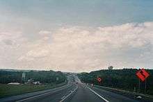
North of the MD 55 intersection, MD 36 meets Interstate 68 at a diamond interchange at exit 34.[1] Near this interchange is God's Ark of Safety, a church famous for its attempt to build a replica of Noah's Ark.[5] Between Midland and Frostburg, the speed limit is again 50 mph (80 km/h),[1] and there is a short section near the Interstate 68 interchange where MD 36 expands to four lanes. Upon entering Frostburg, MD 36 joins U.S. Route 40 Alternate as Main Street. MD 36 follows Main Street westward through Frostburg, meeting the northern terminus of MD 936 at Grant Street. At Depot Street, near the center of Frostburg, MD 36 connects to the western depot of the Western Maryland Scenic Railroad. At the intersection with Water Street, MD 36 leaves U.S. Route 40 Alternate, and upon leaving Frostburg city limits its name changes to Mount Savage Road.[1]
Mount Savage Road
After leaving Frostburg, MD 36 is known as Mount Savage Road, as it travels eastward, perpendicular to its signed direction, toward Mount Savage. North of Eckhart Mines, MD 36 meets MD 638, which connects MD 36 to U.S. Route 40 Alternate in Eckhart Mines.[1] The road between Frostburg and Mount Savage is particularly curvy, and includes several hairpin turns near Frostburg. The speed limit on this section of the road is 35 mph (56 km/h).[1]
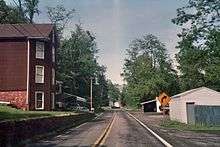
As the road enters Mount Savage, it passes by the Mount Savage Castle, a Scottish-style castle built in 1840, which currently operates as a bed-and-breakfast. In Mount Savage, the route narrows as it follows Main Street,[1] and the road is frequently obstructed by parked cars, making it difficult for two cars to pass by each other. East of Mount Savage, the route widens and its speed limit gradually increases to 50 mph (80 km/h).[1]
In Barrelville, MD 36 intersects MD 47, which connects it with PA 160 in Somerset County.[1] From its intersection with MD 47 to its terminus at Cumberland, MD 36 follows newer alignments, with the old alignments being designated MD 831. At Corriganville, MD 36 intersects MD 35, which connects it with PA 96 in Bedford County.[1] MD 36 ends at U.S. Route 40 Alternate at the Narrows near Cumberland.[1]
History

MD 36 passes through the Georges Creek Valley, which has a long history of coal mining. In recognition of this, the MDSHA has designated MD 36 as part of the Coal Heritage Scenic Byway.[2] Coal mining was a major industry in western Maryland in the 19th century, with railroads being the major route connecting the coal mines to markets outside the Georges Creek Valley.[6] Deep mining, which was the primary mining method used in western Maryland, declined in use after World War II, replaced primarily by surface mining.[7] Although Maryland coal production is now only a small fraction of total U.S. coal production,[7] coal from the Georges Creek Valley is used to power the AES Warrior Run power plant in Cumberland.[8]
MD 36 was assigned a route number before 1927, earlier than most of the other Maryland state highways.[9][10] The original alignment of MD 36 in southern Allegany County closely paralleled the Georges Creek Railroad. Later realignments have shifted MD 36 away from the railroad in several locations, but three crossings remain: one north of Lonaconing, one south of Lonaconing near the MD 935 intersection,[11] and a third crossing near Westernport.[12]
Over the years, multiple new alignments of MD 36 have been built for various reasons, such as to smooth out curves in the road. Several of the old alignments have been assigned route numbers of their own. The southernmost of these is MD 937, which consists of the old alignment through Westernport. Prior to the construction of the bridge connecting MD 36 to WV 46, MD 937 was the alignment of MD 36 through Westernport, ending at MD 135. In Barton, MD 935 carries the old alignment of MD 36. The longest of the old alignment sections is MD 936, which runs from Midland to Frostburg, and was bypassed in the 1970s with a new alignment of MD 36 following part of MD 55 and connecting to Interstate 68. Prior to this change, MD 55 ended in Midland;[13] it has since been truncated to its current terminus at Vale Summit.[14]
North of Frostburg, several old alignments are designated as MD 831, though these segments of road are not signed. Among these segments of road are Kriegbaum Road (designated as MD 831C), and Old Mount Savage Road (designated as MD 831A). Kriegbaum Road splits from MD 36 west of Corriganville and runs through Corriganville, returning to MD 36 east of the town. Old Mount Savage Road intersects MD 36 west of the Cumberland Narrows, and runs southward to intersect U.S. Route 40 Alternate near its current intersection with MD 36.[1]
Junction list
The entire route is in Allegany County.
| Location | mi[1] | km | Destinations | Notes | |
|---|---|---|---|---|---|
| Westernport | 0.00 | 0.00 | Southern terminus; West Virginia state line at Potomac River | ||
| 0.06 | 0.097 | ||||
| 1.44 | 2.32 | Former alignment of MD 36 | |||
| Barton | 4.07 | 6.55 | Former alignment of MD 36 | ||
| Lonaconing | 6.85 | 11.02 | |||
| 8.03 | 12.92 | Douglas Avenue north | Former MD 657 | ||
| Midland | 11.06 | 17.80 | Former alignment of MD 36 | ||
| Vale Summit | 14.04 | 22.60 | |||
| Frostburg | 15.05 | 24.22 | Exit 34 on I-68 | ||
| 16.44 | 26.46 | ||||
| 16.53 | 26.60 | MD 36 joins Alt US 40 | |||
| 17.07 | 27.47 | ||||
| 17.60 | 28.32 | MD 36 leaves Alt US 40 | |||
| Zihlman | 20.36 | 32.77 | |||
| Barrelville | 24.34 | 39.17 | Connects MD 36 to PA 160 | ||
| Corriganville | 26.64 | 42.87 | Officially MD 831C; former alignment of MD 36 | ||
| 27.34 | 44.00 | Connects MD 36 to PA 96 | |||
| 27.51 | 44.27 | Officially MD 831C | |||
| Cumberland | 29.05 | 46.75 | Officially MD 831A; former alignment of MD 36 | ||
| 29.43 | 47.36 | Northern terminus | |||
| 1.000 mi = 1.609 km; 1.000 km = 0.621 mi | |||||
See also
 Maryland Roads portal
References
- 1 2 3 4 5 6 7 8 9 10 11 12 13 14 15 16 17 18 19 20 21 Highway Information Services Division (December 31, 2013). Highway Location Reference. Maryland State Highway Administration. Retrieved October 21, 2010.
- Allegany County (PDF)
- 1 2 Staff (2008). "Coal Heritage Scenic Byway" (PDF). Maryland State Highway Administration. Archived from the original (PDF) on February 21, 2007. Retrieved June 7, 2008.
- ↑ National Highway System: Cumberland, MD (PDF) (Map). Federal Highway Administration. October 1, 2012. Retrieved 2014-09-02.
- ↑ Dilts, James (1996). The Great Road: The Building of the Baltimore and Ohio, the Nation's First Railroad, 1828–1853. Stanford University Press. p. 287. ISBN 0-8047-2629-9.
- ↑ Cleary, Caitlin (April 16, 2006). "If the flood comes too soon, this ark won't be quite ready". Pittsburgh Post-Gazette. Retrieved April 16, 2006.
- ↑ Staff. "Cumberland History". U.S. National Park Service. Retrieved July 25, 2008.
- 1 2 Staff (1997). "Maryland" (PDF). Office of Surface Mining Reclamation and Enforcement. Archived from the original (PDF) on October 8, 2006. Retrieved July 25, 2008.
- ↑ Cannarsa, Andrew (June 30, 2008). "Coal, aggregate industries facing hurdles". Washington Examiner. Retrieved July 25, 2008.
- ↑ Map of Maryland showing the Highways (Map). Maryland Geological Survey. 1910. Archived from the original on August 17, 2008. Retrieved June 30, 2008.
- ↑ Map of Maryland showing State Road system (Map). Maryland Geological Survey. 1927. Archived from the original on August 26, 2008. Retrieved June 8, 2008.
- ↑ Google (June 5, 2008). "Map of crossing near Lonaconing, MD" (Map). Google Maps. Google. Retrieved June 5, 2008.
- ↑ Google (June 5, 2008). "Map of crossing near Westernport, MD" (Map). Google Maps. Google. Retrieved June 5, 2008.
- ↑ Map of Maryland (Map). Cartography by Bureau of Traffic. Maryland State Roads Commission. 1960. Archived from the original on August 26, 2008. Retrieved June 8, 2008.
- ↑ State of Maryland State Highway System (Map). Maryland State Highway Administration. 1979. Archived from the original on August 26, 2008. Retrieved June 30, 2008.
External links
| Wikimedia Commons has media related to Maryland Route 36. |
- Photographs of the section of Route 36 which overlaps with Route 40
- MDRoads.com article on Maryland Route 36