Maryland Route 446
| ||||
|---|---|---|---|---|
| Broad Neck Road | ||||
|
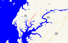
Maryland Route 446 highlighted in red | ||||
| Route information | ||||
| Maintained by MDSHA | ||||
| Length: | 6.03 mi[1] (9.70 km) | |||
| Existed: | 1930 – present | |||
| Major junctions | ||||
| South end: | Langford Bay Road near Langford | |||
| North end: |
| |||
| Location | ||||
| Counties: | Kent | |||
| Highway system | ||||
| ||||

Maryland Route 446 (MD 446) is a state highway in the U.S. state of Maryland. Known as Broad Neck Road, the highway runs 6.03 miles (9.70 km) from Langford Bay Road south of Langford in western Kent County north to MD 20 near Chestertown. The northern half of MD 446 was constructed around 1930. The highway, including a county section that would become an extension of MD 446 in 1988, was resurfaced in 1971.
Route description
MD 446 begins at Broad Neck Road's intersection with Langford Bay Road. The two-lane highway heads north along Broad Neck, a peninsula between the West Fork Branch and East Fork Branch of Langford Creek. MD 446 passes through the hamlet of Langford and crosses Mill Pond Creek shortly before reaching its northern terminus at MD 20 (Chestertown Road) west of Chestertown.[1][2]
History
MD 446 was constructed as a concrete road from MD 20 to south of Langford in 1929 and 1930.[3][4] The highway's construction was partially funded by a $900,000 Kent County bond issue used to construct 9-and-16-foot-wide (2.7 and 4.9 m) concrete roads throughout the county.[3] MD 446 was resurfaced with bituminous concrete in 1971.[5] The resurfacing contract included the resurfacing of the portion of county-maintained Broad Neck Road that was brought into the state highway system as an extension of MD 446 through a December 1, 1987, road transfer agreement.[5][6]
Junction list
The entire route is in Kent County.
| Location | mi[1] | km | Destinations | Notes | |
|---|---|---|---|---|---|
| Langford | 0.00 | 0.00 | Broad Neck Road south / Langford Bay Road west | Southern terminus | |
| Chestertown | 6.03 | 9.70 | Northern terminus | ||
| 1.000 mi = 1.609 km; 1.000 km = 0.621 mi | |||||
See also
 Maryland Roads portal
References
- 1 2 3 Highway Information Services Division (December 31, 2015). Highway Location Reference. Maryland State Highway Administration. Retrieved September 5, 2016.
- Kent County (PDF)
- ↑ Maryland State Highway Administration (2015). Maryland General Highway Statewide Grid Map (PDF) (Map). 1:12,000. Baltimore: Maryland State Highway Administration. §§ E14B, D14D. Retrieved September 5, 2016.
- 1 2 Uhl, G. Clinton; Bruce, Howard; Shaw, John K. (October 1, 1930). Report of the State Roads Commission of Maryland (1927–1930 ed.). Baltimore: Maryland State Roads Commission. pp. 79, 218. Retrieved September 5, 2016.
- ↑ Maryland Geological Survey (1930). Map of Maryland Showing State Road System: State Aid Roads and Improved County Road Connections (Map). Baltimore: Maryland Geological Survey.
- 1 2 Maryland Road Construction Progress Log (PDF). Baltimore: Maryland State Highway Administration. Contract Number: K-326-214/216 (May 27, 1971). Retrieved September 5, 2016 – via Maryland State Archives.
- ↑ "Memorandum of Action of Director Neil J. Pedersen" (PDF). S.R.C. Minutes District No. 2 Kent County. Baltimore: Maryland State Highway Administration. January 19, 1988. Retrieved September 5, 2016 – via Maryland State Archives.