Maryland Route 546
| ||||
|---|---|---|---|---|
| Finzel Road | ||||
|
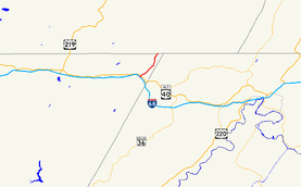
Maryland Route 546 highlighted in red | ||||
| Route information | ||||
| Maintained by MDSHA | ||||
| Length: | 3.61 mi[1] (5.81 km) | |||
| Existed: | 1933 – present | |||
| Major junctions | ||||
| South end: | Beall School Road in Finzel | |||
|
| ||||
| North end: | SR 2010 in Finzel | |||
| Location | ||||
| Counties: | Garrett | |||
| Highway system | ||||
| ||||

Maryland Route 546 (MD 546) is a state highway in the U.S. state of Maryland. Known as Finzel Road, state highway runs 3.61 miles (5.81 km) from Beall School Road south of an interchange with Interstate 68 (I-68) and U.S. Route 40 (US 40) in Finzel in northeastern Garrett County north to the Pennsylvania state line, where the highway continues as State Route 2010 in Somerset County. MD 546 was constructed in the early 1930s. Its southern part followed what is today MD 946; the southern terminus was shifted west when I-68 was constructed in the early 1970s. In 2015, the route was extended a short distance south of the I-68 interchange.
Route description
MD 546 begins at an intersection of Beall School Road and Mels Road, heading northeast on two-lane undivided Finzel Road. The road continues south past the terminus as Beall School Road. A short distance to the northeast, the road intersects the ramps to and from eastbound I-68 and US 40 (National Freeway). MD 546 crosses I-68 then intersects the exit ramp from eastbound I-68 and unsigned MD 546F, a two-way access road to westbound I-68 and US 40 and US 40 Alternate (National Pike). The state highway passes over US 40 Alternate and continues northeast as a two-lane road to an intersection with MD 946 (Finzel Road), the old alignment of MD 546. MD 546 continues north along the ridgeline of Little Savage Mountain through scattered residences and farmland to its northern terminus at the Pennsylvania state line.[1][2] The highway continues north as SR 2010 (Greenville Road) through Greenville Township.[3]
History
MD 546 was constructed as a modern highway in 1933.[4] The state highway originally followed what is now MD 946 to its southern terminus at a standard intersection with US 40 (now US 40 Alternate).[5] MD 946's overpass of US 40 was constructed in 1956 when US 40 was relocated over Little Savage Mountain.[6] MD 546 was relocated to its southern terminus at an interchange with I-68 when the highway's interchange was completed in 1974.[7] In 2015, MD 546 was extended south from the I-68 interchange to the intersection of Beall School Road and Mels Road.[8]
Junction list
The entire route is in Finzel, Garrett County.
| mi [1] | km | Destinations | Notes | ||
|---|---|---|---|---|---|
| 0.00 | 0.00 | Beall School Road south / Mels Road | Southern terminus | ||
| 0.22 | 0.35 | I-68 Exit 29 | |||
| 0.37 | 0.60 | Access road is unsigned MD 546F; I-68 Exit 29 | |||
| 0.81 | 1.30 | ||||
| 3.61 | 5.81 | SR 2010 north (Greenville Road) – Greenville Township | Northern terminus; Pennsylvania state line | ||
| 1.000 mi = 1.609 km; 1.000 km = 0.621 mi | |||||
Auxiliary route
MD 546F is the designation for the unnamed 0.43-mile (0.69 km) access road between MD 546 and US 40 Alternate. The access road includes an entrance ramp to westbound I-68.[1][9] MD 546F was constructed as part of MD 546's interchange with I-68 around 1974.
See also
 Maryland Roads portal
References
- 1 2 3 4 Highway Information Services Division (December 31, 2013). Highway Location Reference. Maryland State Highway Administration. Retrieved 2010-10-27.
- Garrett County (PDF)
- ↑ Google (2010-03-01). "Maryland Route 546" (Map). Google Maps. Google. Retrieved 2010-03-01.
- ↑ General Highway Map: Somerset County, Pennsylvania (PDF) (Map) (2009 ed.). Pennsylvania Department of Transportation. Retrieved 2010-03-01.
- ↑ Byron, William D.; Lacy, Robert (December 28, 1934). Report of the State Roads Commission of Maryland (1931–1934 ed.). Baltimore: Maryland State Roads Commission. p. 336. Retrieved 2010-10-27.
- ↑ Maryland Geological Survey (1933). Map of Maryland Showing State Road System: State Aid Roads and Improved County Road Connections (Map). Baltimore: Maryland Geological Survey.
- ↑ Bonnell, Robert O.; Bennett, Edgar T.; McMullen, John J. (November 2, 1956). Report of the State Roads Commission of Maryland (1955–1956 ed.). Baltimore: Maryland State Roads Commission. p. 189. Retrieved 2010-03-01.
- ↑ Maryland State Highway Administration (1974). Maryland: Official Highway Map (Map). Baltimore: Maryland State Highway Administration.
- ↑ Highway Information Services Division (December 31, 2015). Highway Location Reference. Maryland State Highway Administration. Retrieved 2016-08-10.
- Garrett County (PDF)
- ↑ Google (2010-03-12). "Maryland Route 546F" (Map). Google Maps. Google. Retrieved 2010-03-12.