Max Patch
| Max Patch | |
|---|---|
 Max Patch Bald | |
| Highest point | |
| Elevation | 4,629 ft (1,411 m) [1] |
| Coordinates | 35°47′49″N 82°57′25″W / 35.7970454°N 82.9568108°WCoordinates: 35°47′49″N 82°57′25″W / 35.7970454°N 82.9568108°W [2] |
| Geography | |
| Location | Madison County, North Carolina, U.S. |
| Parent range | Bald Mountains[3] |
| Topo map | USGS Lemon Gap |
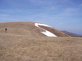
Max Patch is a bald mountain on the North Carolina-Tennessee Border in Madison County, North Carolina and Cocke County, Tennessee. It is a major landmark along the Tennessee/North Carolina section of the Appalachian Trail, although its summit is located in North Carolina. It is known for its 360 degree views of the surrounding mountains, namely the Bald Mountains in the immediate vicinity, the Unakas to the north, the Great Smokies to the south, and the Great Balsams and Black Mountains to the southeast. A small parking area is located near the summit with a short loop trail.
References
- ↑ "Max Patch Mountain, North Carolina". Peakbagger.com. Retrieved 2013-01-15.
- ↑ "Max Patch". Geographic Names Information System. United States Geological Survey. Retrieved July 25, 2008.
- ↑ "Bald Mountains". Geographic Names Information System. United States Geological Survey. Retrieved January 14, 2013.
External links
- Information about hiking and views from the mountain
- Max Patch Mountain – The Heartland Series episode
This article is issued from Wikipedia - version of the 9/7/2015. The text is available under the Creative Commons Attribution/Share Alike but additional terms may apply for the media files.