Meinerzhagen
| Meinerzhagen | ||
|---|---|---|
|
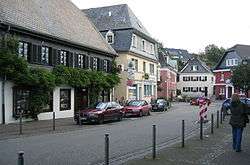
Near the city center | ||
| ||
 Meinerzhagen | ||
Location of Meinerzhagen within Märkischer Kreis district 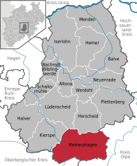
 | ||
| Coordinates: 51°07′N 07°38′E / 51.117°N 7.633°ECoordinates: 51°07′N 07°38′E / 51.117°N 7.633°E | ||
| Country | Germany | |
| State | North Rhine-Westphalia | |
| Admin. region | Arnsberg | |
| District | Märkischer Kreis | |
| Government | ||
| • Mayor | Erhard Pierlings (SPD) | |
| Area | ||
| • Total | 115.18 km2 (44.47 sq mi) | |
| Population (2015-12-31)[1] | ||
| • Total | 20,670 | |
| • Density | 180/km2 (460/sq mi) | |
| Time zone | CET/CEST (UTC+1/+2) | |
| Postal codes | 58540 | |
| Dialling codes |
02354 02358 (Valbert) | |
| Vehicle registration | MK | |
| Website | www.meinerzhagen.de | |

Meinerzhagen (sometimes spelled Meinertzhagen) is a town in the Märkischer Kreis, North Rhine-Westphalia, Germany.
Geography
Meinerzhagen is located in the hills of the Sauerland. The highest elevation is the Nordhelle with 663 m above sea level, the lowest elevation at the Lister dam with 319m. 56% of the district's area is covered by forests.
Neighbouring municipalities
Division of the town
The district consists of the following towns and villages:
|
|
|
|
History
1765 Meinerzhagen received city rights from King Frederick II of Prussia, however in 1865 years later the city abandoned them to save administrative costs. In 1846 the Amt Meinerzhagen was formed, covering both Meinerzhagen and the municipality Valbert. On September 19, 1964 Meinerzhagen received city rights again.
In the communal reform of the district Altena in 1969 Meinerzhagen was merged with Valbert, the Amt Meinerzhagen was dissolved.
The family name of the British World War I officer Richard Meinertzhagen recalls an ancestor who came from this town.
Coat of arms
The coat of arms of Meinerzhagen shows a red lion as the symbol of the dukedom Berg, placed on a blue Andreas cross on yellow ground referring the family von Badinghagen, which expired in the 17th century. The bottom part of the coat of arms shows the red-and-white chequered bordure as the symbol of the Mark. A yellow horn is placed on top of the bordure, taken from the coat of arms of the municipality Valbert. The coat of arms was granted on 14 June 1975.
Before the merging of Meinerzhagen and Valbert, as well as the Amt Meinerzhagen had coat of arms of their own. The coat of arms of Meinerzhagen dates back to at least 1857, as the town hall built in 1857 already showed the coat of arms above the entry. The coat of arms had a green bottom part, above to the left Saint Mary on a throne holding a scepter and Jesus as an infant. To the right was a building with three towers and red roofs, above the sun and two stars.
The coat of arms of the municipality Valbert showed both the chequered bordure as well as the black cross of Cologne in the bottom part, as the municipality consists of parts of the Mark as well as of the bishopric state of Cologne. To the top is a hunter, which as well as the coat of arms of Herscheid refers to the hunting privilege granted by duke Johann III of Cleves, the heir of the duke of Mark. The coat of arms was designed by Otto Hupp, and was granted on 27 October 1935.
The coat of arms of the Amt Meinerzhagen combined symbols of the three historic states of the area. To the bottom is the black cross of Cologne, above the chequered bordure of the Mark, and in top the lion of Berg.
Persons of interest
Meinerzhagen was the birthplace and home of several professional soccer players. Nuri Şahin, Markus Obermeier and Lars Labonte all played for the soccer team of Meinerzhagen before joining professional soccer team Borussia Dortmund.
International relations
1961-2001 Meinerzhagen had a partnership with the Dutch municipality IJsselmuiden. In 2001 IJsselmuiden was incorporated into the city Kampen, which then also continued the partnership.
On 12 April 1987 the documents were signed for the partnership with the French city Saint-Cyr-sur-Loire.
References
- ↑ "Amtliche Bevölkerungszahlen". Landesbetrieb Information und Technik NRW (in German). 18 July 2016.
External links
| Wikimedia Commons has media related to Meinerzhagen. |
- Official site (German)
Towns and municipalities in Märkischer Kreis | ||
|---|---|---|