Melekeok
| Melekeok | ||
|---|---|---|
| State | ||
| ||
 Location of Melekeok in Palau | ||
| Country |
| |
| Capital | Melekeok | |
| Area | ||
| • Total | 11 km2 (4 sq mi) | |
| Population (2005) | ||
| • Total | 391 | |
| • Density | 36/km2 (92/sq mi) | |
| ISO 3166 code | PW-212 | |
Melekeok is a state of the Republic of Palau located on the central east coast of Babeldaob Island. The seat of government of the country Ngerulmud, is located in the state. The state consists of long beaches, hills, steep ridges, rivers and the largest and only natural freshwater lake in the Republic of Palau and Micronesia, Lake Ngardok.
Geography
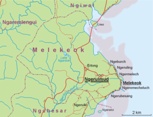
Melekeok is located on the eastern coast of the largest island in the Palau Archipelago, Babeldaob or Babelthuap in some cases. Melekeok State extends from a lagoon, on the east coast, to the Central Divide or Rael Kedam to the west, and is approximately 11 square miles (28 km2) in total area. The state is bordered by Ngiwal State to the north, Ngchesar State to the south, and Ngaremlengui State to the west. The state's coasts consist of long beaches and mangrove forests; the interior consists of swampy marshes, steep, rolling hills covered with sparse vegetation in the interior, and thick forests along the eastern flanks of the Rael Kedam Divide.
Melekeok's Lake Ngardok is the largest natural body of fresh water in all of Micronesia at 4.93 square kilometres (1.90 sq mi); it has a small population of saltwater crocodiles Crocodylus porosus.
State organizations
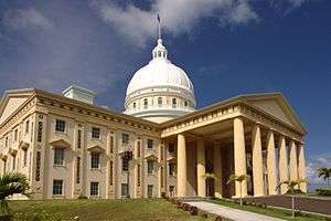
The State of Melekeok consists of eight inhabited villages: Ngeburch, Ngeruling, Ngermelech, Melekeok, Ngerubesang, Ngeremecheluch, Ertong, Ngerulmud. The state capitol is located in the settlement of Ngerulmud. The Republic of Palau's Capitol Complex is located on a hill, northwest of the village of Melekeok.
Demographics
According to the 2005 census, 391 people resided in the State of Melekeok.[1] They are distributed among seven villages, with Melekeok being the largest. The new capital, Ngerulmud, had not been established at the time of the census.
- Melekeok (271)
- Ertong (20)
- Ngeburch (34)
- Ngeremecheluch (38)
- Ngermelech (5)
- Ngerubesang (12)
- Ngeruling (21)
Registered attractions
Odalmelech (Ngermelech Gods carved from Stone), Ngermelech Village; Meteu el Klechem, Melekeok Village; Did el Bad er a Beriber (Ancient Dock's stone bridge), Melekeok Village; Ngermecheluch Site, Ngerang; Bai el Melekeong/Euang el Chades( Melekeok's Bai and its platform of four), Melekeok Village; Lomech er Ngii el mora Ngeremecheluch (ancient stone path), Melekeok Village;
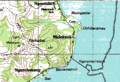 Melekeok area on topographic map
References
- ↑ "Palau Census 2005" (PDF).
External links
| Wikimedia Commons has media related to Melekeok. |
- Seacology Melekeok State Project Seacology
- Melekeok State
- Honorary Consulate of the Republic of Palau to the UK &NI
Coordinates: 7°29′N 134°36′E / 7.483°N 134.600°E