Mendel Glacier
| Mendel Glacier | |
|---|---|
 Mendel Glacier Location in California | |
| Type | Mountain glacier |
| Location | Kings Canyon National Park, Fresno County, California, United States |
| Coordinates | 37°10′42″N 118°40′58″W / 37.17833°N 118.68278°WCoordinates: 37°10′42″N 118°40′58″W / 37.17833°N 118.68278°W |
| Length | .10 mi (0.16 km) |
| Terminus | Talus |
| Status | Retreating |
Mendel Glacier is on the north side of Mount Mendel in the Sierra Nevada, California.[1] The name is commonly used; however, the name is not recognized by the United States Geological Survey in the Geographic Names Information System. Mendel Glacier is .35 miles (0.56 km) north of Darwin Glacier at 12,500 feet (3,800 m) above sea level.
The middle and lower portions of the glacier are covered with rock debris.
An US Army plane crashed above or into the glacier in 1942 with four airmen on board during a navigation training mission.[2]
 Upper Mendel Glacier July, 2006
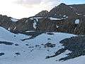 Mendel Glacier Terminus July, 2006
See also
References
- ↑ Mount Darwin, CA (Map). TopoQwest (United States Geological Survey Maps). Retrieved 2012-09-30.
- ↑ Stekel, Peter. "Final Flight". Wilderness Press. Retrieved 2010-03-16.
This article is issued from Wikipedia - version of the 12/24/2015. The text is available under the Creative Commons Attribution/Share Alike but additional terms may apply for the media files.