Mereworth Castle
| Mereworth Castle | |
|---|---|
|
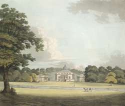
Mereworth Castle in the 18th century | |
 Location of Mereworth Castle in Kent | |
| General information | |
| Type | Country house |
| Architectural style | Palladian |
| Classification | Grade I listed |
| Location | Mereworth, Kent |
| Coordinates | 51°15′14″N 0°23′25″E / 51.25389°N 0.39028°E |
| Construction started | 1723 |
| Completed | 1725 |
| Owner | Mahdi Al-Tajir |
| Design and construction | |
| Architect | Colen Campbell |
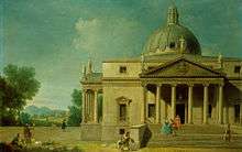
Mereworth Castle is a grade I listed Palladian country house in Mereworth, Kent, England.[1]
History
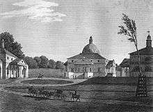

Originally the site of a fortified manor licensed in 1332, the present building is not actually a castle, but was built in the 1720s as an almost exact copy of Palladio's Villa Rotunda.[2] It was designed in 1723 by Colen Campbell who had been commissioned by John Fane, 7th Earl of Westmorland.[3] The interior features plasterwork by Giovanni Bagutti and fresco painting by Francesco Sleter. The house is situated in a landscaped park and valley with a number of surrounding pavilions and lodges which are also Grade I listed.[4][5]
The house passed through descent to Barons Oranmore and Browne whose family seat it became. It was sold in 1930 [6] and used as a prisoner of war camp during World War II.[7] In the 1950s and 1960s it was owned by artist Michael Lambert Tree (1921–1999[8]), a son of Ronald Tree and an heir to the Marshall Field mercantile fortune, and his wife, the former Lady Anne Cavendish, a daughter of the 10th Duke of Devonshire. Tree inherited the house from his uncle, Peter Beatty, who died on 26 October 1949.[9]
The Wateringbury Stream passes through the grounds of the castle. It powered a fulling mill at the eastern end of the castle grounds.[10][11]
Mereworth Castle is owned by Mahdi Al-Tajir, the former United Arab Emirates ambassador to the United Kingdom and owner of the Highland Spring bottled water company,[12] who purchased it in 1976 for $1.2 million.[13] It is not generally accessible to the public, but does open on rare occasions for guided tours.
References
- ↑ "Mereworth Castle (main block) with moat walls to north, Maidstone Road (south side), Mereworth, Tonbridge and Malling, Kent". English Heritage. Retrieved 2008-05-20. This source attributes the plasterwork to Francesco Bagutti, but Giovanni Bagutti would appear to be more likely.
- ↑ 5 houses have been built in Britain based on Palladio's Villa Rotunda (the others being Nuthall Temple, Nottinghamshire [demolished]; Henbury Hall, Cheshire; Chiswick House, Greater London; and Foots Cray Place, Kent [demolished])
- ↑ "The Peerage". The Peerage. Retrieved 2012-02-16.
- ↑ "Images of England, Pavilion to the North East of Mereworth Castle, Maidstone Road (south side), MEREWORTH, Tonbridge and Malling, Kent". English Heritage. Retrieved 2008-05-20.
- ↑ "Pavilion to the North West and Stables of Mereworth Castle, Maidstone Road (south side), MEREWORTH, Tonbridge and Malling, Kent". English Heritage. Retrieved 2008-05-20.
- ↑ Lord Oranmore and Browne's obituary Telegraph
- ↑ "Island farm". Islandfarm.fsnet.co.uk. Retrieved 2012-02-16.
- ↑ Colpus, Eve (2015). "Tree , Lady Anne Evelyn Beatrice (1927–2010)". Oxford Dictionary of National Biography (online ed.). Oxford University Press. doi:10.1093/ref:odnb/103305. Retrieved 21 March 2015. (subscription or UK public library membership required)
- ↑ "British tax may topple castle of a Field heir". Chicago Tribune. 20 June 1952.
- ↑ Watermills of the East Malling and Wateringbury Streams, Part 2, Chapter 1
- ↑ Watermills (Kent and the Borders of Sussex) p134.
- ↑ "Sunday Times Rich List 2010: Britain's richest see wealth rise by one third". The Daily Telegraph. 24 April 2010.
- ↑ Monday, Aug. 02, 1976 (1976-08-02). "BRITAIN: Dinner for 370,000, Please, James". TIME. Retrieved 2012-02-16.
Sources
- Stutchbury, Howard, The Architecture of Colin Campbell, Harvard University Press, 1967, 54-58. ISBN 0-674-04400-2
- Harris, John, The Palladians, Trefoil Publications Ltd, 1981, 66-67. ISBN 0-86294-000-1
- Country Life, XLVII, 808,876,912; XCV, 242; CIV,728; CXVI, 209
- Fuller, Michael (1980). The Watermills of the East Malling and Wateringbury Streams. Maidstone: Christine Swift.
- Fuller & Spain (1986). Watermills (Kent and the Borders of Sussex). Maidstone: Kent Archaeological Society. p. 134. ISBN 0-906746-08-6.
External links
| Wikimedia Commons has media related to Mereworth Castle. |
- Images of England website including a description for listing purposes
- The DiCamillo Companion to British & Irish Country Houses
- York University website entry
- 1930s photographs
Coordinates: 51°15′14″N 0°23′25″E / 51.2539°N 0.3902°E