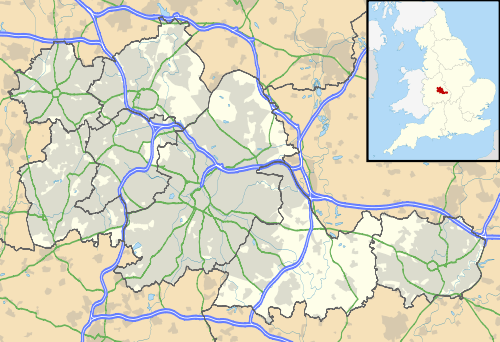
Meriden, West Midlands
| Meriden | |
 The traditional centre of England |
|
 Meriden |
|
| Population | 11,686 (2011.Ward)[1] |
|---|---|
| OS grid reference | SP240824 |
| Civil parish | Meriden |
| Metropolitan borough | Solihull |
| Metropolitan county | West Midlands |
| Region | West Midlands |
| Country | England |
| Sovereign state | United Kingdom |
| Post town | COVENTRY |
| Postcode district | CV7 |
| Dialling code | 01676 |
| Police | West Midlands |
| Fire | West Midlands |
| Ambulance | West Midlands |
| EU Parliament | West Midlands |
| UK Parliament | Meriden |
|
|
Coordinates: 52°26′16″N 1°38′59″W / 52.4379°N 1.6496°W
Meriden is a village and civil parish in the Metropolitan Borough of Solihull, West Midlands, England. It is located between Solihull and the city of Coventry, and is approximately 10 km (6.2 mi) from Birmingham Airport.
The American city of Meriden, Connecticut is named after the village.
History and amenities
Historically part of Warwickshire, the surrounding countryside, known as the Meriden Gap, forms a green belt between the two urban areas of Birmingham and Coventry. It gives its name to the Meriden parliamentary constituency, which covers the Meriden Gap.
The A45 bypass opened in 1958.
In the United Kingdom Census 2001 the population of the Meriden parish was 2,734.
It is possibly the site of an Iron Age field system.
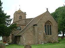
The original name of the village was Alspath and it was centred on the site of the parish church. Over the period 15C to 17C the name 'Meriden' gradually supplants that of Alspath. The parish church of St. Laurence was built on the site of a simple Saxon church erected on her own land by Lady Godiva - the wife of Leofric Earl of Mercia in the years prior to the Norman conquest; however although references to a church/chapel dedicated to St Edmund on the site have been found no physical remains have ever been uncovered. The present church was built in several stages. The nave and two thirds of the chancel were finished by the late 12C - late Norman - and were built as an expiation for sins committed during the civil war between Stephen & Matilda. The chancel was extended in 13C; the south aisle was added in the late 14C. The north aisle was added in the early 15C as was the tower; and the Norman roof was replaced in 15C also. By 1831 the aisles had been rebuilt with galleries and you can see the industrial quality of the stonework outside the building compared to the 14/15C stonework inside. In 1883 the church was restored again and the galleries were removed. At some point the 15C wooden ceilings of both nave and chancel had been plastered over - uncovered during a restoration in 1924; and finally extensive restorations of the medieval roof and tower were carried out circa 2006-10. The St. Laurence/Lawrence (the spelling is interchangeable) to whom the church is dedicated may either be Lawrence of Rome who was one of the seven deacons of the early church martyred during the persecution of Emperor Valerian in 258 A.D.; or it may have been Laurence of Canterbury who became the second archbishop in 604 A.D. Legend favours the latter though, from 1318 onwards, the choice of 10 Aug for the Patronal feast day and the village fair (up until 1959) would indicate the Roman Lawrence; so the issue remains unclear.
Here the Heart of England Way long-distance path wends its way and brings the Staffordshire Heathlands together with the Cotswolds and Forest of Arden.
Meriden is also home to a memorial to all the cyclists who died in the First World War. An annual event, at which thousands of cyclists pay their respects to their fallen colleagues and commemorate these deaths, is held in the village. The memorial was unveiled on 21 May 1921, in the presence of over 20,000 cyclists.
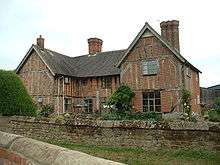
Some moated farmsteads and several timber-framed buildings can be seen in the village.
Triumph motorcycles
From 1941 until 1983, Meriden was home to the large Triumph motorcycles production plant, whose original Priory Street factory in Coventry was earlier destroyed by the Luftwaffe during World War II.
As documented in the book, Forty Summers Ago, the factory was visited by Steve McQueen, Bud Ekins and the rest of the 1964 USA International Six Day Trials team to collect their specially prepared Triumphs. Richard Gere, in an interview promoting his 2002 film Chicago, also claimed to have picked up his Triumph motorcycle from the factory (misidentifying its location), too, albeit in the mid-1970s whilst touring with the Grease stage production.[3]
In 1973, Triumph workers blockaded the factory from the new owners, NVT, to prevent closure. The government loaned the subsequent Meriden Workers Co-Operative money to buy the factory and later to market the Triumph motorcycles they produced.[4] The sit-in and formation of the co-operative were the subject of much media interest including David Edgar's contemporary play, Events Following The Closure Of A Motorcycle Factory.[5] Trading later as Triumph Motorcycles (Meriden) Ltd., the co-operative eventually closed in August 1983,[4] the factory being demolished the following year.[6] The new company, Triumph Motorcycles Ltd was established in 1984, and moved to Hinckley, Leicestershire in 1988.
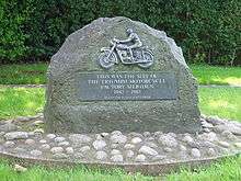
A housing estate has been built on the site of the Triumph motorcycle factory at Meriden. Road names on the estate include Triumph motorcycle model names such as Bonneville Close and Daytona Drive. A plaque commemorating the site's former use stands outside Bonneville Close.[4]
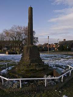
Traditional centre of England
Traditionally Meriden has been regarded as the centre of England. The origins of the tradition are however unclear and as far back as 1821 when a new travel Gazetteer was published the tradition was being referred to as 'legend'. It is admittedly a cross between speculation and educated guesswork but one theory sources 'the legend' as a marketing ploy by a new and energetic manager of the original Bull's Head in the 18C - whether based on an existing understanding or on a piece of brazen fiction. The other theory, whether used as a basis for his marketing ploy or not by the said manager, is based on the importance of the London to Chester road. Crossing the country diagonally as it does the road down to London was an arterial route for livestock being driven in from Wales and down to the South East. Meriden was 3 days from London and 3 days from Chester - so halfway and therefore a 'reasonable bet' for being the centre of the country.
Whatever the actual source of the 'legend' it probably acquired a new lease of life with the advent of cycling as a leisure pursuit for the working populations of the newly industrialised Birmingham and Coventry. These new cycling clubs seized upon the 'legend' and made Meriden an epicentre of social cycling. Even before that however Warwickshire was being written about by poets as being at the centre of the country; and all these elements contribute to the traditional understanding that Meriden is the centre of England.
A sandstone pillar/monument grade II listed [7] on the village green carries a plaque referring to this traditional understanding. The monument was originally located in the old centre of the village near the Pool where road comes in from Berkswell and where cattle would have been watered before carrying on up the hill to the cattle pens at what is now known as Millisons Wood. The monument ('market cross') was moved to what we now know as the village green in 1822 and was moved again to its current position on the green in 1952/3.
Interestingly the traditional understandings of what was the centre of the country in both Roman & Medieval times, and again in the 21C, are all relatively close to each other. In Roman times the centre of the country was deemed to be where Watling Street crossed the Fosse Way (28 miles away from Meriden at High Cross in the outskirts of Leicester); whereas in 2002, the Ordnance Survey formally defined the Geographical Centre of England to be on Lindley Hall Farm, approximately 18 kilometres (11 mi) further north east of Meriden and four miles north of Nuneaton, just off the A5) at Fenny Drayton, Leicestershire.[8] In 2003 the Ordnance Survey went on to identify Church Flatts farm, approximately 35 kilometres (22 mi) north, at Coton in the Elms, southern Derbyshire, as the furthest point from the sea in Great Britain.[9][10]
References
- ↑ "Civil Parish 2011". Retrieved 16 December 2015.
- ↑ Historic England. "Moat House (grade II) (218228)". Images of England.
- ↑ Pearce, Garth; Standard, Evening. "Richard Gere: 'I've finally grown up' | Mail Online". London: Dailymail.co.uk. Retrieved 2012-01-01.
- 1 2 3 Rosamond, John Save The Triumph Bonneville ! The Inside Story Of The Meriden Workers' Co-Op (Veloce 2009)
- ↑ Wilson, Steve British Motorcycles Since 1950 (Vol 5) Triumph: The Company Patrick Stephens Limited (1991) ISBN 1-85260-021-7
- ↑ "Triumph's Last Days" Motorcycle Classics, September/October 2008
- ↑ Historic England. "Medieval cross (grade II) (218231)". Images of England.
- ↑ A tale of two centres
- ↑ BBC report centre of England
- ↑ Ordnance Survey - MapZone
External links
| Wikimedia Commons has media related to Meriden, West Midlands. |