Meshkat
| Meshkat مشكات | |
|---|---|
| city | |
 Meshkat | |
| Coordinates: 34°10′37″N 51°15′54″E / 34.17694°N 51.26500°ECoordinates: 34°10′37″N 51°15′54″E / 34.17694°N 51.26500°E | |
| Country |
|
| Province | Isfahan |
| County | Kashan |
| Bakhsh | Central |
| Population (2006) | |
| • Total | 4,960 |
| Time zone | IRST (UTC+3:30) |
| • Summer (DST) | IRDT (UTC+4:30) |
Meshkat (Persian: مشكات, pronounced /meʃ'ka:t/ with stress on second syllable; also known as Moshkān, Mashgān, and Mashkān)[1] is a city in the Central District of Kashan County, Isfahan Province, Iran. At the 2006 census, its population was 4,960, in 1,299 families.[2]
Situation
Meshkat is the northernmost town of Esfahan Province, Iran. It has a population of 6000, in 2011). It is situated between Qom-Kashan highway (named Amir Kabir Highway) on the South and Qom-Kashan International road on the north; these two main roads connect the north of the country to its south. It is situated in km 25 Kashan-Qom road. Also, it is 195 km (121 mi) south of Tehran, and 250 km (160 mi) north of Esfahan. Meshkat is 880–910 m (2,890–2,990 ft) above sea level.
It has a semi-warm climate. The people of this town are mainly farmers, factory workers or craftsmen. The most important agricultural products of Meshkat include wheat, pomegranate, greengage, cotton, among others. It is endowed with several brooks some of which are flowing all year long. Trees of various types help moderate the temperature in hot season; when passing by the thick vegetation areas beside the main road to meshkat, one could easily feel the considerable drop of temperature.
Recently, a Calcium Bicarbonate Factory has been built near this town, promising prosperous economic future for the town. Meshkat is southerly limited to the Tehran-Ghom-Esfahan Expressway, while the main asphalt road, which connects Tehran to the south of the country, passes directly through this town. Also, a railroad passes by the northern side of the Meshkat's suburbs.
References
- ↑ Meshkat can be found at GEOnet Names Server, at this link, by opening the Advanced Search box, entering "-3074257" in the "Unique Feature Id" form, and clicking on "Search Database".
- ↑ "Census of the Islamic Republic of Iran, 1385 (2006)". Islamic Republic of Iran. Archived from the original (Excel) on 2011-11-11.
External links
| Capital | 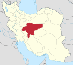 | ||||||||||||||||||||||||||||||||||||||||||||||||||||||||||||||
|---|---|---|---|---|---|---|---|---|---|---|---|---|---|---|---|---|---|---|---|---|---|---|---|---|---|---|---|---|---|---|---|---|---|---|---|---|---|---|---|---|---|---|---|---|---|---|---|---|---|---|---|---|---|---|---|---|---|---|---|---|---|---|---|
| Counties (A-L) and cities | |||||||||||||||||||||||||||||||||||||||||||||||||||||||||||||||
| Counties (M-Z) and cities | |||||||||||||||||||||||||||||||||||||||||||||||||||||||||||||||
| Landmarks and sights |
| ||||||||||||||||||||||||||||||||||||||||||||||||||||||||||||||
| populated places | |||||||||||||||||||||||||||||||||||||||||||||||||||||||||||||||