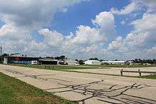
Meyers–Diver's Airport
Coordinates: 42°01′30.25″N 83°56′20.99″W / 42.0250694°N 83.9391639°W
| Meyers–Diver's Airport | |||||||||||||||
|---|---|---|---|---|---|---|---|---|---|---|---|---|---|---|---|
 Meyers–Diver's Airport | |||||||||||||||
| IATA: none – ICAO: none – FAA LID: 3TE | |||||||||||||||
| Summary | |||||||||||||||
| Airport type | Public | ||||||||||||||
| Owner | Al Meyers Airport Inc. | ||||||||||||||
| Operator | Keith Diver | ||||||||||||||
| Serves | Tecumseh, Michigan | ||||||||||||||
| Elevation AMSL | 815 ft / 248 m | ||||||||||||||
| Coordinates | 42°01′30.25″N 83°56′20.99″W / 42.0250694°N 83.9391639°W | ||||||||||||||
| Runways | |||||||||||||||
| |||||||||||||||
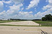
Meyers–Diver's Airport is located in Tecumseh, Michigan. It is owned by Al Meyers Airport, Inc. and managed by Andy Alto. Mr Alto purchased the airport in 2014. In January 2015 Andy Alto banned skydiving from the airport with no regard for area residents or businesses. It has an FAA identifier of 3TE. It is at an elevation of 815 feet. It has two runways; one with an asphalt surface and a length of 2,660 feet and the other with a turf surface and a length of 1,820 feet.[1] The airport is a skydiving drop zone.[2]

In the early 1950s the airport was the location of the Meyers Aircraft Company, where the Meyers MAC-145 was produced. [3] The airport was formerly named the Al Meyers Airport after the founder of Meyers Aircraft Co.[4]
References
External links
| Wikimedia Commons has media related to Meyers–Diver's Airport. |