Mi'kma'ki
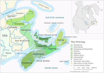
Mi'kma'ki or Mi'gma'gi is the national territory of the Mi'kmaq (or Mi'gmaq), a First Nation in Eastern Canada. It is divided into seven geographical and traditional districts. Historically, each district had its own independent government with its chief and its council. District chiefs gathered together to form the Grand Council called Sante Mawiomi.
Districts
Mi'kma'ki is divided into seven districts (names are given in the Franci-Smith orthography with the Listuguj orthography in brackets) :
- Epkwitk aq Piktuk (Epegwitg aq Pigtug)
- Eskikewa'kik (Esge'gewa'gi)
- Kespek (Gespe'gewa'gi)
- Kespukwitk (Gespugwitg)
- Siknikt (Signigtewa'gi)
- Sipekni'katik (Sugapune'gati)
- Unama'kik (Unama'gi)
Futhermore, sometimes an eight district is added: Taqamkuk (Gtaqamg).
History
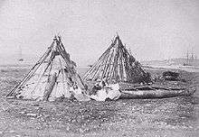
Traditionally, the seven district of the Mi'kmaq territory each had their own independent governments. Those governments were composed of a chief and a council. The council included the band chiefs, elders and important leaders of the community. The role of the councils was similar to those of any independent government and included to edict laws, establish a justice system, divide the territory for hunting and fishing, make war and search for peace. In addition to those councils, there was also a the Grand Council Sante Mawiomi that was compose of the keptinaq (captains), the district chiefs. In addition to those, the Grand Council also comprised elders, putus (historians reading the belts) and a women council. The Grand Council was leaded by a grand chief who was one of the district chief, generally the chief of Unama'kik District. The system of transfers was hereditary. The seat of the Grand Council was generally on the Cape Breton Island.[1]