Middle Fork Salmon River
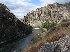
The Middle Fork of the Salmon River is a 104-mile-long (167 km)[1] river in central Idaho in the northwestern United States. The Middle Fork lies in the center of the 2.5 million acre Frank Church-River of No Return Wilderness. Designated by the United States Congress as a federally protected wilderness in 1980, it is part of the largest roadless area left in the lower 48 states.
| Middle Fork Salmon River | |
| Stream | |
 | |
| Country | United States |
|---|---|
| State | Idaho |
| Source | |
| - coordinates | 44°26′57″N 115°13′51″W / 44.44917°N 115.23083°W |
| Mouth | Salmon River |
| - elevation | 3,015 ft (919 m) |
| - coordinates | 45°17′50″N 114°35′36″W / 45.29722°N 114.59333°WCoordinates: 45°17′50″N 114°35′36″W / 45.29722°N 114.59333°W |
| [2] | |
Course
The Middle Fork is a tributary of the Salmon River, which is the main tributary of the Snake River, which in turn is the main tributary to the Columbia River. The Middle Fork is one hundred miles of whitewater. The nearest town is Stanley, Idaho. The Middle Fork's elevation starts at 7,000 feet (2,100 m) above sea level and drops down to 3,900 feet (1,200 m). Bear Valley Creek and Marsh Creek converge to form the Middle Fork. The Middle Fork has around a hundred tributaries; some of the bigger tributaries are Rapid River, Loon Creek and Camas Creek. These three tributaries range from 20 to 25 miles (32 to 40 km) long. The Middle Fork flows through 2,500 square miles (6,500 km2) of rugged terrain known as the Salmon River Mountains, in which there are peaks that reach as high as 10,000 feet (3,000 m) (Midmore 1–2).
Permit
A permit is required to travel down the Middle Fork of the Salmon River, which can be obtained through the Four Rivers Lottery and Permit Reservation System. The Middle Fork of the Salmon River permit season runs from May 28 - Sept. 3. Pre and the post season launches are first-come, first-served.[3] Getting a recreational permit to float the Middle Fork is notoriously difficult and is awarded through a lottery system. There are a combined total of seven commercial and recreational launches a day. To become a permit holder you have to be 18 years old. The permit holder must work with a group to take care of the fees. The permit cannot be given to someone else, and the permit holder must be there at all times on the river. The permit holder must make sure that the rules, which are given by the United States Forest Service, are followed. An example would be that they must have a fire pan and port-a-potty.
Commercial river outfitters for the Middle Fork of the Salmon at http://www.idahosmiddlefork.com/
Rapids
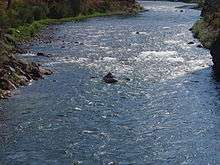
The Middle Fork has three hundred raftable rapids. Some of the well-known rapids on the Middle Fork are Dagger Falls, Sulphur Slide, Velvet Falls, the Chutes, Power House, Pistol Creek, Tappan Falls, Red Side, Weber, Cliffside, Rubber, Hancock and Devil's Tooth. All but one of these are class III+ to class IV (on a scale of I to VI), with Dagger Falls being class V.
Hot Springs
The Middle Fork has six natural hot springs in the first 52 miles (84 km) of the river, Trail Flat, Sheepeater, Sunflower, Whitey Cox, Loon Creek and Hospital Bar. The hot springs vary in temperature and are all very popular places to stop on the river.
- Trail Flat hot springs is 30 yards (27 m) from the river and has one pool.
- Sheepeater hot springs is a half a mile from the river. There are three different pools which range from "super hot" to "just right".
- Sunflower hot springs has five pools. There is also a part of the hot spring that pours off the rocks and makes a shower.
- Whitey Cox's hot springs is up on a hill with large sandy-bottom pools which can hold a lot of people.
- Loon Creek hot springs is a mile-and-a-half hike along Loon Creek from the Middle Fork. A wooden tub has been built with a nice view of Loon Creek.
- Hospital Bar is a small hot spring with two pools, one right next to the river.
Mammals
Vegetation
Fish
- Cutthroat trout
- Rainbow trout, includes steelhead
- Mountain whitefish
- Bull trout
- Chinook salmon
Birds
See also
References
- ↑ http://www.fs.usda.gov/recarea/scnf/recarea/?recid=77793
- ↑ U.S. Geological Survey Geographic Names Information System: Middle Fork Salmon River. Retrieved 2008-04-04.
- ↑ Middle Fork of the Salmon River, USDA Forest Service
Notes
- Midmore, Joe. Middle Fork History. Harrah's Club Inc. Lake Tahoe, NV, 1970.
- Quinn, James M. Quinn, James W. Quinn, Terry L. and king James G. Handbook to the Middle Fork of the Salmon River Canyon. Commercial Printing Company Medford, OR, 1981.
- Sierra Club. International Whitewater Rating Systems. 2003
- USDA Forest Service. The Middle Fork of the Salmon River. 8 January 2008