Middle Harbour
| Middle Harbour (Warring-Ga[1]) | |
| Semi-mature tide dominated, drowned valley estuary[2] | |
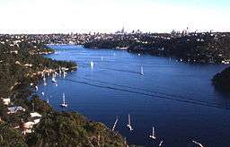 Middle Harbour seen from behind Seaforth Oval. | |
| Country | Australia |
|---|---|
| State | New South Wales |
| Region | Greater Metropolitan Sydney |
| Municipalities | Ku-ring-gai, Northern Beaches Council, Mosman, North Sydney, Willoughby |
| Source | Middle Harbour Creek |
| - location | Bungaroo |
| - coordinates | 33°47′40.38″S 151°13′57.18″E / 33.7945500°S 151.2325500°E |
| Mouth | Port Jackson |
| - location | Grotto Point near Clontarf, Middle Head |
| - coordinates | 33°48′15.624″S 151°14′58.2″E / 33.80434000°S 151.249500°ECoordinates: 33°48′15.624″S 151°14′58.2″E / 33.80434000°S 151.249500°E |
| Length | 10 km (6 mi) |
| Basin | 100 km2 (39 sq mi) |
Middle Harbour (or Warring-Ga),[1] a semi–mature tide dominated drowned valley estuary,[2] is the northern arm of Port Jackson, an inlet of the Tasman Sea located north of Sydney central business district on the coast of New South Wales, Australia.
Middle Harbour has its source in the upper reaches of Garigal National Park where it forms Middle Harbour Creek and flows southeast to become Middle Harbour at Bungaroo and travels for approximately 10 kilometres (6.2 mi) before reaching its mouth at Port Jackson between Grotto Point near Clontarf and Middle Head.
The catchment area of Middle Harbour is approximately 100 square kilometres (39 sq mi).
Geography
Course
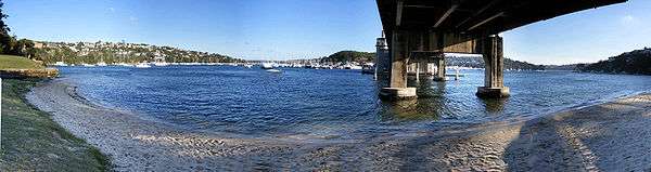
The shore of Middle Harbour is nearly everywhere rugged, barren and forested and for this reason Middle Harbour was almost entirely neglected during the first two centuries of European settlement in Sydney. There are only a few small patches of flat land on its shores. There are many small creeks draining the surrounding hills, but no significant rivers flow into Middle Harbour.
Within Middle Harbour are, from upstream to downstream, Shell Cove, Pearl Bay, Long Bay, Sugarloaf Bay, Bantry Bay, Fisher Bay, Sandy Bay, Sailors Bay, Powder Hulk Bay, Willoughby Bay and Quakers Hat Bay.[1]
Middle Harbour is a significant physical barrier between Sydney and the suburbs known as the Northern Beaches area which lie north and east of Middle Harbour.
There are only two bridges - the Spit Bridge and the Roseville Bridge. Because of this obstacle, historically the main transport between Manly and Sydney was by ferry.
Since the 1920s, most of the land on the ridge-tops around Middle Harbour have been developed for suburban housing. Much of the rugged shore of the Middle Harbour remains covered with bushland, most of it now protected by parks and reserves. Middle Harbour is a popular area for recreational boating and fishing.
See also
References
- 1 2 3 "Middle Harbour". Geographical Names Register (GNR) of NSW. Geographical Names Board of New South Wales. Retrieved 5 January 2013.
- 1 2 Roy, P. S; Williams, R. J; Jones, A. R; Yassini, I; et al. (2001). "Structure and Function of South-east Australian Estuaries". Estuarine, Coastal and Shelf Science. 53: 351–384. doi:10.1006/ecss.2001.0796.
External links
- "Sydney Harbour and Parramatta River catchment" (map). Office of Environment and Heritage. Government of New South Wales.
- NSW State of the Beaches 2011–2012: Sydney Estuarine Beaches region p. 242
- Sydney Metropolitan Catchment Management Authority