Middle Teton Glacier
| Middle Teton Glacier | |
|---|---|
|
Middle Teton Glacier | |
 Middle Teton Glacier | |
| Type | Mountain glacier |
| Coordinates | 43°43′57″N 110°48′16″W / 43.73250°N 110.80444°WCoordinates: 43°43′57″N 110°48′16″W / 43.73250°N 110.80444°W[1] |
| Terminus | Moraine |
| Status | Retreating |
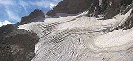
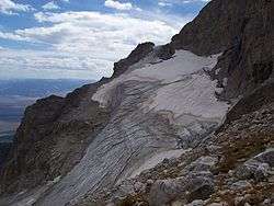
Middle Teton Glacier is on the northeast flank of Middle Teton in Grand Teton National Park, Wyoming.[2] The alpine glacier is a popular mountaineering route for ice climbing and for access to the summit of Middle Teton and other peaks to the south. The glacier is at the west end of Garnet Canyon, which is the most popular route used by climbers ascending Grand Teton. The glacier melt feeds streams below including Spalding Falls, an 80 ft (24 m) high cascade. Between 1967 and 2006, Middle Teton Glacier lost approximately 25 percent of its surface area, shrinking from 52 to 39 acres (21 to 16 ha).[3]
Middle Teton Glacier from the north
See also
References
- ↑ "Middle Teton Glacier". Geographic Names Information System. United States Geological Survey. Retrieved 2012-08-12.
- ↑ Grand Teton, WY (Map). TopoQwest (United States Geological Survey Maps). Retrieved 2012-08-12.
- ↑ Edmunds, Jake; et al. (February 2012). "Glacier Variability (1967–2006) in the Teton Range, Wyoming, United States". Journal of the American Water Resources Association. 48 (1): 187–196. doi:10.1111/j.1752-1688.2011.00607.x. Retrieved 2013-02-15.
This article is issued from Wikipedia - version of the 9/1/2015. The text is available under the Creative Commons Attribution/Share Alike but additional terms may apply for the media files.