Middle Village–Metropolitan Avenue (BMT Myrtle Avenue Line)
| Middle Village–Metropolitan Avenue | |||||||||||||||
|---|---|---|---|---|---|---|---|---|---|---|---|---|---|---|---|
| New York City Subway rapid transit station | |||||||||||||||
|
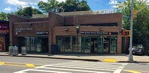
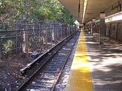
View of Middle Village–Metropolitan Avenue Subway Station from across Metropolitan Avenue | |||||||||||||||
| Station statistics | |||||||||||||||
| Address |
67-28 Metropolitan Avenue Queens, NY 11379 | ||||||||||||||
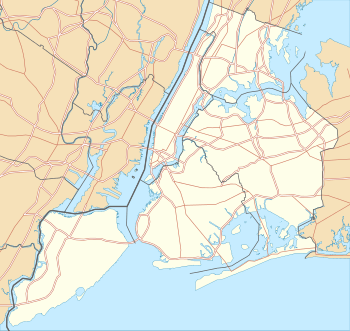
| Borough | Queens | ||||||||||||||
| Locale | Middle Village | ||||||||||||||
| Coordinates | 40°42′44″N 73°53′21″W / 40.712232°N 73.889194°WCoordinates: 40°42′44″N 73°53′21″W / 40.712232°N 73.889194°W | ||||||||||||||
| Division | B (BMT) | ||||||||||||||
| Line | BMT Myrtle Avenue Line | ||||||||||||||
| Services |
M | ||||||||||||||
| Transit connections |
| ||||||||||||||
| Structure | At-grade at northern end; western side sloped into an embankment at southern end | ||||||||||||||
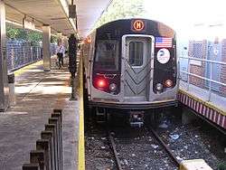
| Platforms | 1 island platform | ||||||||||||||
| Tracks | 2 | ||||||||||||||
| Other information | |||||||||||||||
| Opened | October 1, 1906[1] | ||||||||||||||
| Rebuilt |
August 9, 1915 1980 | ||||||||||||||
| Accessible |
| ||||||||||||||
| Traffic | |||||||||||||||
| Passengers (2015) |
1,361,246[2] | ||||||||||||||
| Rank | 321 out of 422 | ||||||||||||||
| Station succession | |||||||||||||||
| |||||||||||||||
| |||||||||||||||
| |||||||||||||||


Middle Village–Metropolitan Avenue is a terminal station of the BMT Myrtle Avenue Line of the New York City Subway. Located at the intersection of Metropolitan Avenue and Rentar Plaza in Middle Village, Queens, it is served by the M train at all times.
History
The station originally opened on October 1, 1906, to serve the adjacent Lutheran cemetery. It was part of an extension of the line past Wyckoff Avenue along a former steam dummy surface line.[1] A second station opened on August 9, 1915, west of the original facility,[1] while the other former surface stations were elevated. On July 16, 1974, a fire completely destroyed the original wooden platform and station house along with R27 cars 8202, 8203, 8237 and R30 car 8512 along with some fire damage done to R32 cars 3549, 3659, 3694 and 3695, and the station had to be completely rebuilt.[3] It reopened in 1980 with the current concrete platform and brick stationhouse.
By railroad and service directions, it is the southern terminal of the Myrtle Avenue Line and M train, respectively. However, it was the northern terminal of the M train by service direction before its reroute on June 27, 2010.[4][5][6][7] During late night service, this is the M train's northern terminal by geographic direction, as the service's other terminus, Myrtle Avenue, is geographically further south.
Station layout
| G Street Level |
Exit/ Entrance | Fare control, station agent, platform level |
| Track 2 | ← | |
| Island platform, doors will open on the left, right | ||
| Track 1 | ← | |
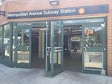
The station, built on an embankment with the north end at street level,[1][3] has two tracks and a concrete island platform with benches. The tracks end at bumper blocks at the north end of the platform. A steel canopy with fluorescent lights and supported by silver columns covers the entire platform. The grade-level station house, the station's only entrance, is made of bricks with glass windows,[8] located at the eastern corner of Rentar Plaza and Metropolitan Avenue.[9] It has two pairs of doors leading to the platform, turnstile bank and token booth. Also, there are two pairs of doors out to the street corner and another door along Metropolitan Avenue. Because the station house is at ground level and the platform extends out of the station house, this station is fully ADA-accessible, but does not have an elevator or ramp.[10]
On the side of the westernmost track opposite from the platform is an employee-only facility. The control tower for the Myrtle Avenue Line is at the south end of the platform. Just to the south of the station lies the Fresh Pond Yard. It is only accessible from this station, so trains coming from Manhattan and Brooklyn must first enter the station, then reverse into the yard.
Points of interest
Directly adjacent to the station is the New York Connecting Railroad, which travels north in an open-cut. South of the station, it becomes continuous with the Long Island Rail Road's Bay Ridge Branch.[8][9] Past the station on its east side is Christ the King Regional High School.[8][9] Directly to the west of the station is Metro Mall, a large shopping mall with relatively few stores. The station is located at Metropolitan Avenue's intersection with Rentar Plaza, which is the access road to the mall's parking lots.[8][9][11] The Lutheran All Faiths Cemetery is located on the northern and eastern sides of the station.[8][9][11]
References
- 1 2 3 4 "New L Train Service to Lutheran Cemetery: B.R.T. Opens a Line To-morrow That Takes Passengers Into Queens County.". Brooklyn Daily Eagle. September 30, 1906. p. 33. Retrieved 28 September 2015 – via Newspapers.com.
- ↑ "Facts and Figures: Annual Subway Ridership". Metropolitan Transportation Authority. Retrieved 2016-04-19.
- 1 2 "12 Passengers Led to Safety After Fire On Train Platform". The New York Times. July 17, 1974. Retrieved 28 September 2015.
- ↑ "Memorandum: Modifications to 2010 NYC Transit Service Reductions" (PDF). mta.info. MTA New York City Transit Authority. March 19, 2010. Retrieved 23 August 2015.
- ↑ Grynbaum, Michael M. (March 19, 2010). "Under a New Subway Plan, the V Stands for Vanished". The New York Times. Retrieved 2010-03-20.
- ↑ "2010 NYC Transit Service Reductions" (PDF). mta.info. Metropolitan Transportation Authority. January 27, 2010. Archived from the original (PDF) on 2010-11-25. Retrieved 2 August 2015.
- ↑ "Review of the G Line" (PDF). mta.info. Metropolitan Transportation Authority. July 10, 2013. Retrieved 2 August 2015.
- 1 2 3 4 5 Dave Frattini (27 May 2014). The Underground Guide to New York City Subways. St. Martin's Press. pp. 213–. ISBN 978-1-4668-7249-3.
- 1 2 3 4 5 "MTA Neighborhood Maps: Ridgewood" (PDF). Metropolitan Transportation Authority. 2015. Retrieved 28 September 2015.
- ↑ "NYC Official Accessibility Guide" (PDF). nyc.gov. City of New York. 2008. Retrieved 20 September 2015.
- 1 2 "SUBWAY-SIDEWALK INTERFACE PROJECT TECHNICAL MEMORANDUM IV ISSUES AND OPPORTUNITIES" (PDF). transalt.org. New York City Department of City Planning,. November 2000. Retrieved 6 December 2015.
External links
| Wikimedia Commons has media related to Middle Village – Metropolitan Avenue (BMT Myrtle Avenue Line). |
- nycsubway.org – BMT Myrtle Avenue Line: Metropolitan Avenue
- Station Reporter — M train
- The Subway Nut — Middle Village–Metropolitan Avenue Pictures
- Metropolitan Avenue entrance from Google Maps Street View