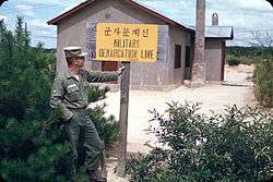
Military Demarcation Line

| Military Demarcation Line | |
| Hangul | 군사분계선 / 휴전선 |
|---|---|
| Hanja | 軍事分界線 / 休戰線 |
| Revised Romanization | Gunsabungyeseon / Hyujeonseon |
| McCune–Reischauer | Kunsabungyesŏn / Hyujŏnsŏn |
The Military Demarcation Line (MDL), sometimes referred to as the Armistice Line, is the land border or demarcation line between North Korea and South Korea. On either side of the line is the Korean Demilitarized Zone (DMZ). The MDL and DMZ were established by the Armistice at the end of the Korean War in 1953.[1]
In the Yellow Sea, the two Koreas are divided by a de facto maritime "military demarcation line" and maritime boundary called the Northern Limit Line (NLL) drawn by the United Nations Command in 1953.[2] The NLL is not described by the Korean Armistice Agreement.[3]
Demarcation on land

The DMZ runs near the 38th parallel, covering roughly 248 kilometers.[4] American and South Korean soldiers patrol this line along the South Korean side while North Korean soldiers patrol along the North Korean side.
In Korean, the line is called the Hyujeonseon (휴전선), meaning "armistice line."[5] It is also sometimes called the Gunsa Bungye-seon (군사분계선), which literally means "military demarcation line." However, in colloquial usage, the dividing line is more often called the Sampalseon (삼팔선, "38th parallel"), a name likely coined at the end of World War II, when it would have been an accurate description of the North-South border.
The line itself is marked off by a series of 1,292 identical signs which are placed at intervals across the peninsula. The north facing side of the signs are written in Korean and Chinese, and in Korean and English on the south facing side. The signs are now aging and rusting.
Military incidents
There have been frequent skirmishes along the line since the armistice ended the fighting of the Korean War.
Northern Limit Line

A: United Nations Command-created Northern Limit Line, 1953[7]
B: North Korea-declared "Inter-Korean MDL", 1999[8] The locations of specific islands are reflected in the configuration of each maritime boundary, including ----
Although the Korean Armistice Agreement specifies where the demarcation line and demilitarized zone are located on land, the agreement does not mention lines or zones in adjacent ocean waters.[9] Shortly after the signing of the Armistice, a line in the sea was drawn unilaterally by the United Nations Command (UNC).[10] This Northern Limit Line or North Limit Line (NLL) represented the northern limit of the area in which South Korea permits its vessels to navigate, not a demarcation line on which the two Koreas agreed.[11] The Korean Armistice Agreement (KAA) provisions regarding the MDL and DMZ do not extend into the Yellow Sea or Sea of Japan.[12]
In 1999, North Korea unilaterally asserted its own "North Korean Military Demarcation Line in the West Sea (Yellow Sea)",[13] also called the "Inter-Korean MDL in the Yellow Sea".[14]
Nonetheless, the UNC-drawn line functions as a de facto or "practical" extension of the 1953 MDL, despite occasional incursions and clashes.[15]
See also
Notes
- ↑ The MDL was defined and established in the Korean Armistice Agreement (KAA), Article I, paragraphs 1–11. The KAA includes provisions regarding the MDL and DMZ; but those provisions do not extend into the Yellow Sea or the Sea of Japan. The subsequently devised Northern Boundary Line or NLL was neither initially conceived as part of the MDL, nor have the DPRK and UNC agreed to any subsequent extension of the MDL beyond the agreed upon limits of 1953/7/27.
- ↑ Ryoo, Moo Bong. (2009). "The Korean Armistice and the Islands," p. 5. Strategy research project at the U.S. Army War College; excerpt, "Strategic Consequences of the Agreement. The agreement to retain the five islands under UNC control has shaped many aspects of the security environment of the Korean Peninsula. The most obvious and prominent consequence is the establishment of the Northern Limit Line (NLL). The NLL has served as a practical maritime borderline and an effective means to separate the forces and thus prevent military clashes between th two Koreas"; compare Kim, Kwang-Tae. "After Exchange of Fire, N. Korea Threatens More Strikes on South," Time (US). November 23, 2010.
- ↑ Pak, Hŭi-gwŏn. (2000). The Law of the Sea and Northeast Asia: a Challenge for Cooperation, p. 108, p. 108, at Google Books; excerpt, "Under the 1953 Armistice Agreement, the Military Demarcation Line was drawn across the Korean peninsula. Since no maritime demarcation line was specified in the Armistice Agreement, however, the United Nations Command drew the NLL...."
- ↑ "Korean War History". Retrieved 2006-01-12.
- ↑ See, e.g., Dictionary – Definition of armistice.
- ↑ Ryoo, p. 13.
- ↑ "Factbox: What is the Korean Northern Limit Line?" Reuters (UK). November 23, 2010; retrieved 26 Nov 2010.
- ↑ Van Dyke, Jon et al. "The North/South Korea Boundary Dispute in the Yellow (West) Sea," Marine Policy 27 (2003), 143–158; note that "Inter-Korean MDL" is cited because it comes from an academic source and the writers were particular enough to include in quotes as we present it. The broader point is that the maritime demarcation line here is NOT a formal extension of the Military Demarcation Line; compare "NLL—Controversial Sea Border Between S.Korea, DPRK, " People's Daily (PRC), November 21, 2002; retrieved 22 Dec 2010
- ↑ Glionna, John M. "Sea border a trigger for Korean peninsula tension," Los Angeles Times (US). January 6, 2011; retrieved 2011-07-28
- ↑ Kim Young-koo. "A Maritime Demarcation Dispute on the Yellow Sea: Republic of Korea," Journal of East Asia and International Law (JEAIL), Volume 2, Number 2.
- ↑ "Modern meaning of Korea’s maritime line," The Hankyoreh (ROK). October 15, 2007.
- ↑ In principle, the UNC and PRK could agree to extend the MDL into the Yellow Sea (IAW para. 62 of the KAA); however, there is no such agreement.
- ↑ Zou, Keyuan. (2005). Law of the Sea in East Asia: Issues and Prospects, p. 7, p. 7, at Google Books; excerpt, "In response to the unilateral NLL, the North Korean authorities declared after the 1999 incident (on 2 September 1999), that they had set up a 'North Korean Military Demarcation Line in the West Sea (Yellow Sea)' which overlaps with the existing NLL"; Lee, Hy-Sang Lee. (2001). North Korea: a Strange Socialist Fortress, p. 191, p. 191, at Google Books; "South Korea is a criminal without principle." – Noth Korea", Sir Lanka Guardian, November 25, 2010.
- ↑ "NLL—Controversial Sea Border Between S.Korea, DPRK, " People's Daily (PRC), 2002-11-21; retrieved 2010-11-26.
- ↑ Ryoo, p. 11; excerpt, "The NLL has served as an effective means of preventing military tension between North and South Korean military forces for 46 years. It serves as a practical demarcation line, which has contributed to the separation of forces." --1999. 6. 11, United Nations Command (Korea); Aigner, Erin and Haeoun Park. "Military Strike in the Waters Between North and South Korea," New York Times. November 23, 2010; Williams, David and Peter Simpson. "Korea on the brink: South warns of retaliation after North's shellfire strike kills two marines," Daily Mail (UK). November 24, 2010; retrieve 22 Dec 2010.
References
- Lee, Hy-Sang Lee. (2001). North Korea: a Strange Socialist Fortress. Westport, Connecticut: Praeger. ISBN 978-0-275-96917-2; OCLC 237388400
- Pak, Hŭi-gwŏn. (2000). The Law of the Sea and Northeast Asia: a Challenge for Cooperation. Boston: Kluwer Law International. ISBN 978-90-411-1407-5; OCLC 154667938
- Van Dyke, Jon M., Mark J. Valencia and Jenny Miller Garmendia. "The North/South Korea Boundary Dispute in the Yellow (West) Sea," . Marine Policy 27 (2003), 143–158.
- Zou, Keyuan Zou. (2005). Law of the Sea in East Asia: Issues and Prospects. London: Routledge. ISBN 978-0-415-35074-7; OCLC 55960798