Minami-Chitose Station
Minami-Chitose Station 南千歳駅 | |
|---|---|
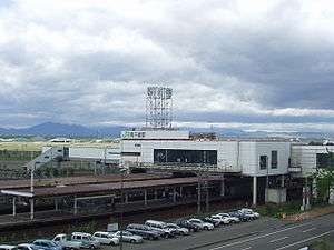
 Station building, May 2004 | |
| Location |
Chitose, Hokkaido Japan |
| Operated by |
|
| Line(s) |
|
| Distance | 18.4 km from Numanohata |
| Platforms | 2 island platforms |
| Tracks | 4 |
| Other information | |
| Status | Staffed |
| Station code | H14 |
| History | |
| Opened | October 1, 1980 |
| Traffic | |
| Passengers (FY2012) | 1,460 daily |
| Location | |
 Minami-Chitose Station Location within Japan | |
Minami-Chitose Station (南千歳駅 Minami-chitose-eki) is a railway station in Chitose, Hokkaido, Japan, operated by Hokkaido Railway Company (JR Hokkaido).
Lines
Minami-Chitose Station is served by the Chitose Line and Sekishō Line. The station is numbered "H14".[1]
Limited express trains
- Super Ōzora (Sapporo - Kushiro)
- Super Tokachi (Sapporo - Obihiro)
- Super Hokuto (Sapporo - Hakodate)
- Suzuran (Sapporo - Muroran)
Station layout
Cross-platform interchange at Minami-Chitose Station
The station consists of two island platforms serving four tracks, with the station situated above the tracks. The station has automated ticket machines, automated turnstiles which accept Kitaca,[2] and a "Midori no Madoguchi" staffed ticket office.
Platforms
| 1 | ■ Chitose Line | for Tomakomai and Higashi-Muroran |
| ■ Chitose Line Airport branch | for New Chitose Airport | |
| ■ Sekishō Line | for Oiwake, Yūbari, and Obihiro | |
| 2 | ■ Chitose Line | for Sapporo and Otaru |
| ■ Chitose Line Airport branch | for New Chitose Airport | |
| ■ Sekishō Line | for Oiwake | |
| 3 | ■ Chitose Line | for Sapporo and Otaru |
| ■ Chitose Line Airport branch | for New Chitose Airport | |
| 4 | ■ Chitose Line | for Sapporo and Otaru |
Adjacent stations
| « | Service | » | ||
|---|---|---|---|---|
| Chitose Line | ||||
| Bibi (H15) | Local | Chitose (H13) | ||
| Chitose Line Airport blanch | ||||
| New Chitose Airport (AP15) | Rapid Airport | Chitose (H13) | ||
| Sekishō Line | ||||
| Terminus | - | Oiwake (K15) | ||
References
- ↑ "JR Hokkaido Route Map" (PDF). Hokkaido Railway Company. Retrieved 2016-11-19.
- ↑ "Service Range Kitaca". JR Hokkaido. Retrieved 2016-11-19.
Coordinates: 42°48′29.3″N 141°40′31″E / 42.808139°N 141.67528°E
This article is issued from Wikipedia - version of the 11/20/2016. The text is available under the Creative Commons Attribution/Share Alike but additional terms may apply for the media files.