Mirza Ali Kandi
| Mirza Ali Kandi ميرزاعلي كندي | |
|---|---|
| village | |
|
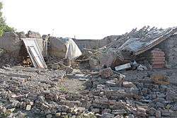
damage from the 2012 East Azerbaijan earthquakes. | |
 Mirza Ali Kandi | |
| Coordinates: 38°27′03″N 46°39′43″E / 38.45083°N 46.66194°ECoordinates: 38°27′03″N 46°39′43″E / 38.45083°N 46.66194°E | |
| Country |
|
| Province | East Azerbaijan |
| County | Varzaqan |
| Bakhsh | Central |
| Rural District | Ozomdel-e Jonubi |
| Population (2006) | |
| • Total | 271 |
| Time zone | IRST (UTC+3:30) |
| • Summer (DST) | IRDT (UTC+4:30) |
Mirza Ali Kandi (Persian: ميرزاعلي كندي, also Romanized as Mīrzā ‘Alī Kandī; also known as Marzā ‘Alī Kandī, Merzā ‘Alī Kandī, Mizārli Kand, Mizārli Kandi, and Mizarli-Kendy)[1] is a village in Ozomdel-e Jonubi Rural District, in the Central District of Varzaqan County, East Azerbaijan Province, Iran. At the 2006 census, its population was 271, in 57 families.[2]
The village was damaged in the 2012 East Azerbaijan earthquakes.
References
- ↑ Mirza Ali Kandi can be found at GEOnet Names Server, at this link, by opening the Advanced Search box, entering "-3075166" in the "Unique Feature Id" form, and clicking on "Search Database".
- ↑ "Census of the Islamic Republic of Iran, 1385 (2006)". Islamic Republic of Iran. Archived from the original (Excel) on 2011-11-11.
This article is issued from Wikipedia - version of the 10/18/2013. The text is available under the Creative Commons Attribution/Share Alike but additional terms may apply for the media files.