Missouri Route 95
| ||||
|---|---|---|---|---|
| Route information | ||||
| Maintained by MoDOT | ||||
| Length: | 94 mi (151 km) | |||
| Major junctions | ||||
| South end: |
| |||
|
| ||||
| North end: |
| |||
| Highway system | ||||
| ||||

Route 95 is a highway in southern Missouri. Its northern terminus is at Route 32 at Lynchburg in Laclede County. Its southern terminus is at U.S. Route 160 at Lutie about 2.5 miles west of the Theodosia arm of Bull Shoals Lake in Ozark County.[1]
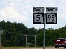
Wrong way concurrency sign on Missouri routes 5 and 95 at Wasola, Missouri
A short 3.3 miles (5.3 km) section forms a wrong-way concurrency with Route 5; Route 95 is marked as "North Route 95" and actually goes south at this location.
History
The section of Route 95 north of Wasola to Lutie was originally a section of Route 5A, a branch of Route 5.
References
- ↑ Ava, Missouri, 30x60 Minute Topographic Quadrangle, USGS, 1985
This article is issued from Wikipedia - version of the 6/30/2014. The text is available under the Creative Commons Attribution/Share Alike but additional terms may apply for the media files.